You are here: Home > Network List > KZ - Kazakhstan Network Stations List
> Station AKTK Aktyubinsk, Kazakstan > Earthquake Result Viewer
AKTK Aktyubinsk, Kazakstan - Earthquake Result Viewer
| Earthquake location: |
Sea Of Okhotsk |
| Earthquake latitude/longitude: |
46.8/145.4 |
| Earthquake time(UTC): |
2000/07/10 (192) 09:58:18 GMT |
| Earthquake Depth: |
360 km |
| Earthquake Magnitude: |
6.1 MB, 5.9 MW, 5.8 MW |
| Earthquake Catalog/Contributor: |
WHDF/NEIC |
|
| Network: |
KZ Kazakhstan Network |
| Station: |
AKTK Aktyubinsk, Kazakstan |
| Lat/Lon: |
50.43 N/58.02 E |
| Elevation: |
360 m |
|
| Distance: |
54.6 deg |
| Az: |
308.427 deg |
| Baz: |
57.261 deg |
| Ray Param: |
0.063956216 |
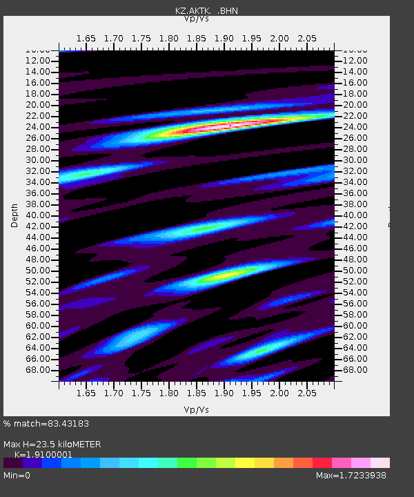
| Estimated Moho Depth: |
23.5 km |
| Estimated Crust Vp/Vs: |
1.91 |
| Assumed Crust Vp: |
6.353 km/s |
| Estimated Crust Vs: |
3.326 km/s |
| Estimated Crust Poisson's Ratio: |
0.31 |
|
| Radial Match: |
83.43183 % |
| Radial Bump: |
400 |
| Transverse Match: |
75.544525 % |
| Transverse Bump: |
400 |
| SOD ConfigId: |
3744 |
| Insert Time: |
2010-03-09 08:42:22.555 +0000 |
| GWidth: |
2.5 |
| Max Bumps: |
400 |
| Tol: |
0.001 |
|

Signal To Noise
| Channel | StoN | STA | LTA |
| KZ:AKTK: :BHN:20000710T10:06:41.052988Z | 14.808998 | 6.736809E-7 | 4.5491323E-8 |
| KZ:AKTK: :BHE:20000710T10:06:41.052988Z | 16.399273 | 6.9482536E-7 | 4.2369276E-8 |
| KZ:AKTK: :BHZ:20000710T10:06:41.052988Z | 29.402071 | 1.606598E-6 | 5.464234E-8 |
| Arrivals |
| Ps | 3.5 SECOND |
| PpPs | 10 SECOND |
| PsPs/PpSs | 14 SECOND |


