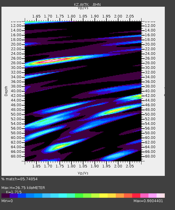
AKTK Aktyubinsk, Kazakstan - Earthquake Result Viewer

Earthquake location: Near S. Coast Of Honshu, Japan
Earthquake latitude/longitude: 34.2/139.1
Earthquake time(UTC): 2000/07/01 (183) 07:01:55 GMT
Earthquake Depth: 10 km
Earthquake Magnitude: 6.0 MB, 6.1 MS, 6.2 MW, 6.2 MW
Earthquake Catalog/Contributor: WHDF/NEIC
Network: KZ Kazakhstan Network
Station: AKTK Aktyubinsk, Kazakstan
Lat/Lon: 50.43 N/58.02 E
Elevation: 360 m
Distance: 59.2 deg
Az: 312.637 deg
Baz: 72.407 deg
Ray Param: 0.06235396
Estimated Moho Depth: 26.75 km
Estimated Crust Vp/Vs: 1.72
Assumed Crust Vp: 6.353 km/s
Estimated Crust Vs: 3.704 km/s
Estimated Crust Poisson's Ratio: 0.24
Radial Match: 85.74854 %
Radial Bump: 385
Transverse Match: 71.181046 %
Transverse Bump: 400
SOD ConfigId: 3744
Insert Time: 2010-03-09 08:42:25.984 +0000
GWidth: 2.5
Max Bumps: 400
Tol: 0.001

Signal To Noise

ChannelStoNSTALTA
KZ:AKTK: :BHN:20000701T07:11:25.535017Z1.58273785.6937424E-83.597401E-8
KZ:AKTK: :BHE:20000701T07:11:25.535017Z3.0909871.3102841E-74.2390475E-8
KZ:AKTK: :BHZ:20000701T07:11:25.535017Z15.1706673.1802097E-72.0962887E-8
Arrivals
Ps3.2 SECOND
PpPs11 SECOND
PsPs/PpSs14 SECOND