You are here: Home > Network List > IU - Global Seismograph Network (GSN - IRIS/USGS) Stations List
> Station PMG Port Moresby, New Guinea > Earthquake Result Viewer
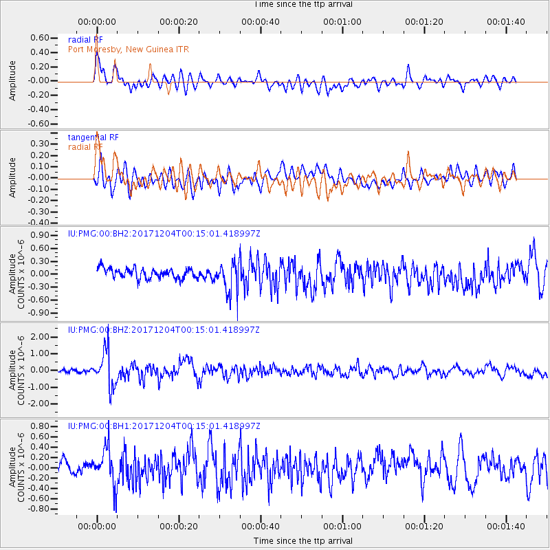
PMG Port Moresby, New Guinea - Earthquake Result Viewer
*The percent match for this event was below the threshold and hence no stack was calculated.
| Earthquake location: |
South Of Kermadec Islands |
| Earthquake latitude/longitude: |
-32.8/-178.7 |
| Earthquake time(UTC): |
2017/12/04 (338) 00:08:04 GMT |
| Earthquake Depth: |
10 km |
| Earthquake Magnitude: |
5.7 Mww |
| Earthquake Catalog/Contributor: |
NEIC PDE/us |
|
| Network: |
IU Global Seismograph Network (GSN - IRIS/USGS) |
| Station: |
PMG Port Moresby, New Guinea |
| Lat/Lon: |
9.40 S/147.16 E |
| Elevation: |
90 m |
|
| Distance: |
39.1 deg |
| Az: |
298.804 deg |
| Baz: |
131.61 deg |
| Ray Param: |
$rayparam |
*The percent match for this event was below the threshold and hence was not used in the summary stack. |
|
| Radial Match: |
74.72204 % |
| Radial Bump: |
400 |
| Transverse Match: |
63.75824 % |
| Transverse Bump: |
400 |
| SOD ConfigId: |
2429771 |
| Insert Time: |
2017-12-18 00:09:26.465 +0000 |
| GWidth: |
2.5 |
| Max Bumps: |
400 |
| Tol: |
0.001 |
|
Signal To Noise
| Channel | StoN | STA | LTA |
| IU:PMG:00:BHZ:20171204T00:15:01.418997Z | 9.848 | 1.0913559E-6 | 1.1082006E-7 |
| IU:PMG:00:BH1:20171204T00:15:01.418997Z | 2.7146704 | 3.6317388E-7 | 1.3378194E-7 |
| IU:PMG:00:BH2:20171204T00:15:01.418997Z | 3.0961769 | 3.6005443E-7 | 1.1629E-7 |
| Arrivals |
| Ps | |
| PpPs | |
| PsPs/PpSs | |


