You are here: Home > Network List > KZ - Kazakhstan Network Stations List
> Station AKTK Aktyubinsk, Kazakstan > Earthquake Result Viewer
AKTK Aktyubinsk, Kazakstan - Earthquake Result Viewer
| Earthquake location: |
South Of Mariana Islands |
| Earthquake latitude/longitude: |
12.7/145.0 |
| Earthquake time(UTC): |
2001/10/12 (285) 15:02:16 GMT |
| Earthquake Depth: |
37 km |
| Earthquake Magnitude: |
6.7 MB, 7.3 MS, 7.0 MW, 6.9 MW |
| Earthquake Catalog/Contributor: |
WHDF/NEIC |
|
| Network: |
KZ Kazakhstan Network |
| Station: |
AKTK Aktyubinsk, Kazakstan |
| Lat/Lon: |
50.43 N/58.02 E |
| Elevation: |
360 m |
|
| Distance: |
78.4 deg |
| Az: |
319.317 deg |
| Baz: |
84.153 deg |
| Ray Param: |
0.049601585 |
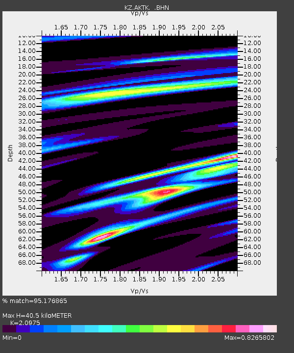
| Estimated Moho Depth: |
40.5 km |
| Estimated Crust Vp/Vs: |
2.10 |
| Assumed Crust Vp: |
6.353 km/s |
| Estimated Crust Vs: |
3.029 km/s |
| Estimated Crust Poisson's Ratio: |
0.35 |
|
| Radial Match: |
95.176865 % |
| Radial Bump: |
400 |
| Transverse Match: |
81.379974 % |
| Transverse Bump: |
400 |
| SOD ConfigId: |
20082 |
| Insert Time: |
2010-03-09 08:42:42.215 +0000 |
| GWidth: |
2.5 |
| Max Bumps: |
400 |
| Tol: |
0.001 |
|

Signal To Noise
| Channel | StoN | STA | LTA |
| KZ:AKTK: :BHN:20011012T15:13:42.644016Z | 13.907747 | 7.3617935E-7 | 5.293304E-8 |
| KZ:AKTK: :BHE:20011012T15:13:42.644016Z | 35.406002 | 2.8501636E-6 | 8.0499454E-8 |
| KZ:AKTK: :BHZ:20011012T15:13:42.644016Z | 146.91162 | 7.967166E-6 | 5.4231016E-8 |
| Arrivals |
| Ps | 7.2 SECOND |
| PpPs | 19 SECOND |
| PsPs/PpSs | 26 SECOND |


