You are here: Home > Network List > US - United States National Seismic Network Stations List
> Station AMTX Amarillo, Texas, USA > Earthquake Result Viewer
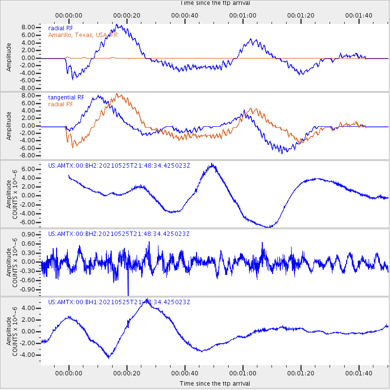
AMTX Amarillo, Texas, USA - Earthquake Result Viewer
*The percent match for this event was below the threshold and hence no stack was calculated.
| Earthquake location: |
Tonga Islands |
| Earthquake latitude/longitude: |
-17.6/-174.8 |
| Earthquake time(UTC): |
2021/05/25 (145) 21:36:44 GMT |
| Earthquake Depth: |
200 km |
| Earthquake Magnitude: |
5.7 mww |
| Earthquake Catalog/Contributor: |
NEIC PDE/us |
|
| Network: |
US United States National Seismic Network |
| Station: |
AMTX Amarillo, Texas, USA |
| Lat/Lon: |
34.53 N/101.41 W |
| Elevation: |
1010 m |
|
| Distance: |
86.8 deg |
| Az: |
52.414 deg |
| Baz: |
246.289 deg |
| Ray Param: |
$rayparam |
*The percent match for this event was below the threshold and hence was not used in the summary stack. |
|
| Radial Match: |
43.637993 % |
| Radial Bump: |
400 |
| Transverse Match: |
38.925194 % |
| Transverse Bump: |
400 |
| SOD ConfigId: |
25028951 |
| Insert Time: |
2021-06-08 21:55:33.649 +0000 |
| GWidth: |
2.5 |
| Max Bumps: |
400 |
| Tol: |
0.001 |
|
Signal To Noise
| Channel | StoN | STA | LTA |
| US:AMTX:00:BHZ:20210525T21:48:34.425023Z | 1.9001607 | 2.5463729E-7 | 1.340083E-7 |
| US:AMTX:00:BH1:20210525T21:48:34.425023Z | 6.323862 | 3.2691646E-6 | 5.1695696E-7 |
| US:AMTX:00:BH2:20210525T21:48:34.425023Z | 3.518992 | 3.820763E-6 | 1.085755E-6 |
| Arrivals |
| Ps | |
| PpPs | |
| PsPs/PpSs | |


