You are here: Home > Network List > KZ - Kazakhstan Network Stations List
> Station AKTK Aktyubinsk, Kazakstan > Earthquake Result Viewer
AKTK Aktyubinsk, Kazakstan - Earthquake Result Viewer
| Earthquake location: |
Northwest Of Kuril Islands |
| Earthquake latitude/longitude: |
47.8/146.2 |
| Earthquake time(UTC): |
2002/11/17 (321) 04:53:53 GMT |
| Earthquake Depth: |
459 km |
| Earthquake Magnitude: |
7.3 MW, 7.3 MW |
| Earthquake Catalog/Contributor: |
WHDF/NEIC |
|
| Network: |
KZ Kazakhstan Network |
| Station: |
AKTK Aktyubinsk, Kazakstan |
| Lat/Lon: |
50.43 N/58.02 E |
| Elevation: |
360 m |
|
| Distance: |
54.4 deg |
| Az: |
308.21 deg |
| Baz: |
55.893 deg |
| Ray Param: |
0.063595645 |
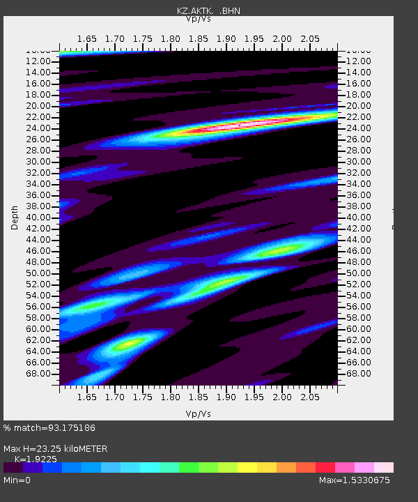
| Estimated Moho Depth: |
23.25 km |
| Estimated Crust Vp/Vs: |
1.92 |
| Assumed Crust Vp: |
6.353 km/s |
| Estimated Crust Vs: |
3.305 km/s |
| Estimated Crust Poisson's Ratio: |
0.31 |
|
| Radial Match: |
93.175186 % |
| Radial Bump: |
400 |
| Transverse Match: |
81.928566 % |
| Transverse Bump: |
400 |
| SOD ConfigId: |
4714 |
| Insert Time: |
2010-03-09 08:43:22.532 +0000 |
| GWidth: |
2.5 |
| Max Bumps: |
400 |
| Tol: |
0.001 |
|

Signal To Noise
| Channel | StoN | STA | LTA |
| KZ:AKTK: :BHN:20021117T05:02:05.652Z | 97.26825 | 6.372814E-6 | 6.551792E-8 |
| KZ:AKTK: :BHE:20021117T05:02:05.652Z | 148.52954 | 6.9464127E-6 | 4.6767887E-8 |
| KZ:AKTK: :BHZ:20021117T05:02:05.652Z | 272.15436 | 1.8744198E-5 | 6.887341E-8 |
| Arrivals |
| Ps | 3.5 SECOND |
| PpPs | 10 SECOND |
| PsPs/PpSs | 14 SECOND |


