You are here: Home > Network List > G - GEOSCOPE Stations List
> Station RER Riviere de l'Est, La Reunion (Indian Ocean) > Earthquake Result Viewer
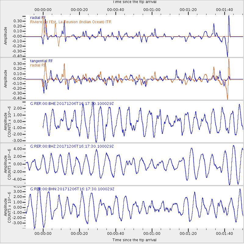
RER Riviere de l'Est, La Reunion (Indian Ocean) - Earthquake Result Viewer
*The percent match for this event was below the threshold and hence no stack was calculated.
| Earthquake location: |
Minahassa Peninsula, Sulawesi |
| Earthquake latitude/longitude: |
-0.6/123.7 |
| Earthquake time(UTC): |
2017/12/06 (340) 16:06:55 GMT |
| Earthquake Depth: |
18 km |
| Earthquake Magnitude: |
5.6 mb |
| Earthquake Catalog/Contributor: |
NEIC PDE/us |
|
| Network: |
G GEOSCOPE |
| Station: |
RER Riviere de l'Est, La Reunion (Indian Ocean) |
| Lat/Lon: |
21.16 S/55.75 E |
| Elevation: |
834 m |
|
| Distance: |
69.2 deg |
| Az: |
247.68 deg |
| Baz: |
82.321 deg |
| Ray Param: |
$rayparam |
*The percent match for this event was below the threshold and hence was not used in the summary stack. |
|
| Radial Match: |
62.79915 % |
| Radial Bump: |
400 |
| Transverse Match: |
63.805798 % |
| Transverse Bump: |
374 |
| SOD ConfigId: |
2429771 |
| Insert Time: |
2017-12-20 16:07:20.392 +0000 |
| GWidth: |
2.5 |
| Max Bumps: |
400 |
| Tol: |
0.001 |
|
Signal To Noise
| Channel | StoN | STA | LTA |
| G:RER:00:BHZ:20171206T16:17:30.100029Z | 0.88549966 | 1.874853E-6 | 2.1172825E-6 |
| G:RER:00:BHN:20171206T16:17:30.100029Z | 2.9754028 | 2.321552E-6 | 7.8024794E-7 |
| G:RER:00:BHE:20171206T16:17:30.100029Z | 1.6568676 | 2.0083962E-6 | 1.2121645E-6 |
| Arrivals |
| Ps | |
| PpPs | |
| PsPs/PpSs | |


