You are here: Home > Network List > XW97 - Tien Shan Continental Dynamics Stations List
> Station KSA XW.KSA > Earthquake Result Viewer
KSA XW.KSA - Earthquake Result Viewer
| Earthquake location: |
E. Russia-N.E. China Border Reg. |
| Earthquake latitude/longitude: |
43.6/130.4 |
| Earthquake time(UTC): |
1999/04/08 (098) 13:10:34 GMT |
| Earthquake Depth: |
566 km |
| Earthquake Magnitude: |
6.4 MB, 7.1 MW, 7.1 MW |
| Earthquake Catalog/Contributor: |
WHDF/NEIC |
|
| Network: |
XW Tien Shan Continental Dynamics |
| Station: |
KSA XW.KSA |
| Lat/Lon: |
41.54 N/77.93 E |
| Elevation: |
3398 m |
|
| Distance: |
38.1 deg |
| Az: |
285.528 deg |
| Baz: |
68.803 deg |
| Ray Param: |
0.07288155 |
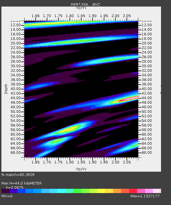
| Estimated Moho Depth: |
44.0 km |
| Estimated Crust Vp/Vs: |
2.07 |
| Assumed Crust Vp: |
6.491 km/s |
| Estimated Crust Vs: |
3.139 km/s |
| Estimated Crust Poisson's Ratio: |
0.35 |
|
| Radial Match: |
90.3929 % |
| Radial Bump: |
400 |
| Transverse Match: |
78.26328 % |
| Transverse Bump: |
400 |
| SOD ConfigId: |
4480 |
| Insert Time: |
2010-02-26 15:37:50.101 +0000 |
| GWidth: |
2.5 |
| Max Bumps: |
400 |
| Tol: |
0.001 |
|
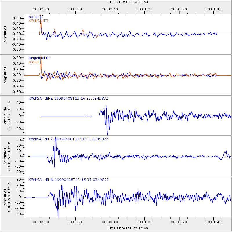
Signal To Noise
| Channel | StoN | STA | LTA |
| XW:KSA: :BHZ:19990408T13:16:35.034987Z | 91.78261 | 1.0751496E-5 | 1.17140885E-7 |
| XW:KSA: :BHN:19990408T13:16:35.034987Z | 30.156622 | 1.50947E-6 | 5.0054346E-8 |
| XW:KSA: :BHE:19990408T13:16:35.034987Z | 83.01708 | 5.0751783E-6 | 6.113414E-8 |
| Arrivals |
| Ps | 7.7 SECOND |
| PpPs | 20 SECOND |
| PsPs/PpSs | 27 SECOND |


