You are here: Home > Network List > TA - USArray Transportable Network (new EarthScope stations) Stations List
> Station A36M Sachs Harbour, NT, CAN > Earthquake Result Viewer
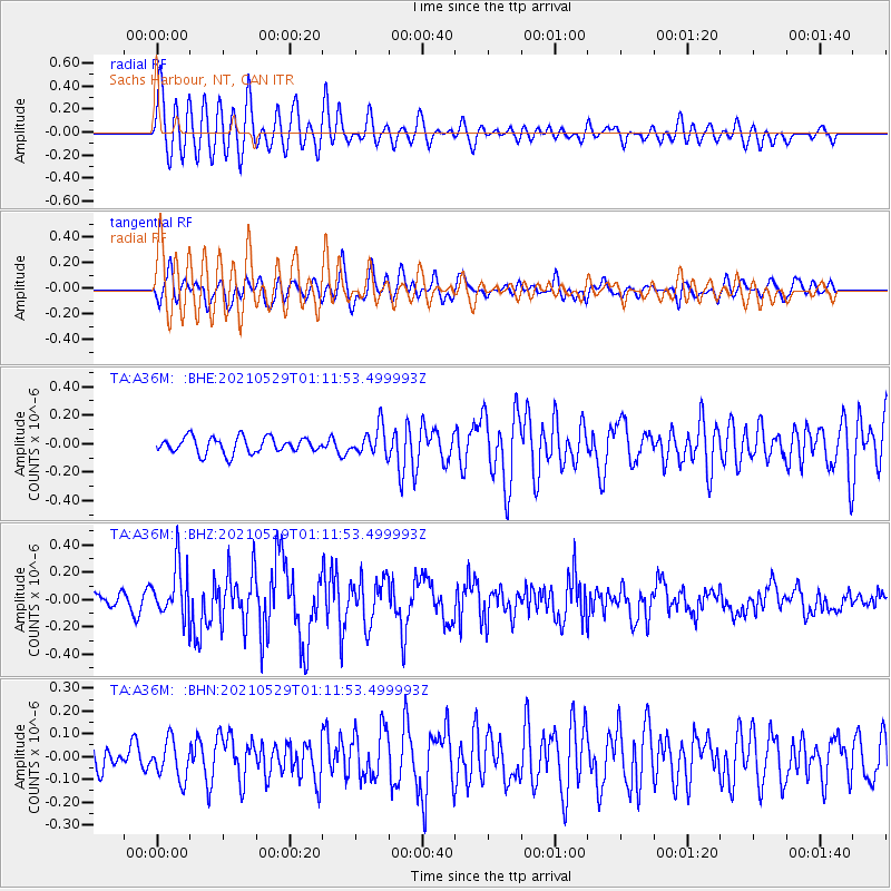
A36M Sachs Harbour, NT, CAN - Earthquake Result Viewer
*The percent match for this event was below the threshold and hence no stack was calculated.
| Earthquake location: |
Off East Coast Of Honshu, Japan |
| Earthquake latitude/longitude: |
36.3/142.0 |
| Earthquake time(UTC): |
2021/05/29 (149) 01:02:40 GMT |
| Earthquake Depth: |
7.5 km |
| Earthquake Magnitude: |
5.5 mww |
| Earthquake Catalog/Contributor: |
NEIC PDE/us |
|
| Network: |
TA USArray Transportable Network (new EarthScope stations) |
| Station: |
A36M Sachs Harbour, NT, CAN |
| Lat/Lon: |
71.99 N/125.25 W |
| Elevation: |
32 m |
|
| Distance: |
56.7 deg |
| Az: |
21.818 deg |
| Baz: |
285.252 deg |
| Ray Param: |
$rayparam |
*The percent match for this event was below the threshold and hence was not used in the summary stack. |
|
| Radial Match: |
77.36442 % |
| Radial Bump: |
400 |
| Transverse Match: |
65.16767 % |
| Transverse Bump: |
400 |
| SOD ConfigId: |
25028951 |
| Insert Time: |
2021-06-12 01:18:51.248 +0000 |
| GWidth: |
2.5 |
| Max Bumps: |
400 |
| Tol: |
0.001 |
|
Signal To Noise
| Channel | StoN | STA | LTA |
| TA:A36M: :BHZ:20210529T01:11:53.499993Z | 4.3187613 | 1.9041778E-7 | 4.4090832E-8 |
| TA:A36M: :BHN:20210529T01:11:53.499993Z | 1.2058555 | 8.4349814E-8 | 6.995018E-8 |
| TA:A36M: :BHE:20210529T01:11:53.499993Z | 1.7700839 | 9.901522E-8 | 5.593815E-8 |
| Arrivals |
| Ps | |
| PpPs | |
| PsPs/PpSs | |


