You are here: Home > Network List > CI - Caltech Regional Seismic Network Stations List
> Station MPM Manuel Prospect Mine, California, USA > Earthquake Result Viewer
MPM Manuel Prospect Mine, California, USA - Earthquake Result Viewer
| Earthquake location: |
Central Alaska |
| Earthquake latitude/longitude: |
62.4/-148.3 |
| Earthquake time(UTC): |
2021/05/31 (151) 06:59:54 GMT |
| Earthquake Depth: |
44 km |
| Earthquake Magnitude: |
6.1 Mww |
| Earthquake Catalog/Contributor: |
NEIC PDE/ak |
|
| Network: |
CI Caltech Regional Seismic Network |
| Station: |
MPM Manuel Prospect Mine, California, USA |
| Lat/Lon: |
36.06 N/117.49 W |
| Elevation: |
185 m |
|
| Distance: |
32.6 deg |
| Az: |
129.683 deg |
| Baz: |
333.791 deg |
| Ray Param: |
0.07851126 |
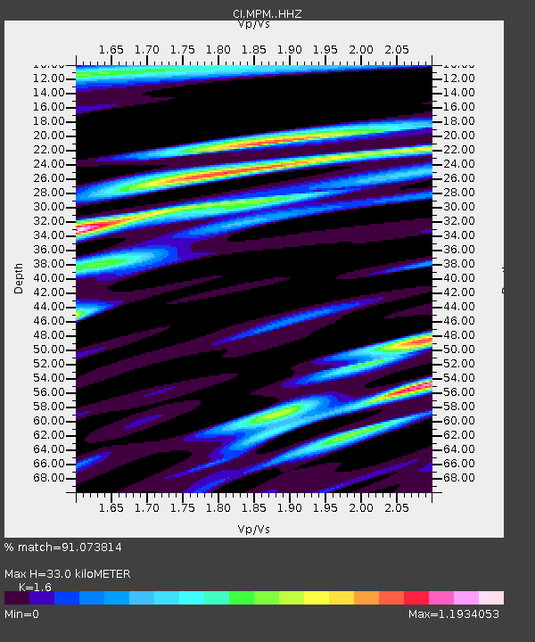
| Estimated Moho Depth: |
33.0 km |
| Estimated Crust Vp/Vs: |
1.60 |
| Assumed Crust Vp: |
6.279 km/s |
| Estimated Crust Vs: |
3.924 km/s |
| Estimated Crust Poisson's Ratio: |
0.18 |
|
| Radial Match: |
91.073814 % |
| Radial Bump: |
400 |
| Transverse Match: |
81.96238 % |
| Transverse Bump: |
400 |
| SOD ConfigId: |
25028951 |
| Insert Time: |
2021-06-14 07:02:53.541 +0000 |
| GWidth: |
2.5 |
| Max Bumps: |
400 |
| Tol: |
0.001 |
|

Signal To Noise
| Channel | StoN | STA | LTA |
| CI:MPM: :HHZ:20210531T07:05:51.647995Z | 12.971422 | 1.3562153E-6 | 1.045541E-7 |
| CI:MPM: :HHN:20210531T07:05:51.647995Z | 11.343295 | 7.962396E-7 | 7.019473E-8 |
| CI:MPM: :HHE:20210531T07:05:51.647995Z | 4.6740327 | 5.790461E-7 | 1.2388575E-7 |
| Arrivals |
| Ps | 3.4 SECOND |
| PpPs | 13 SECOND |
| PsPs/PpSs | 16 SECOND |


