You are here: Home > Network List > CI - Caltech Regional Seismic Network Stations List
> Station SWS Sam W. Stewart, Westmorland, CA, USA > Earthquake Result Viewer
SWS Sam W. Stewart, Westmorland, CA, USA - Earthquake Result Viewer
| Earthquake location: |
Central Alaska |
| Earthquake latitude/longitude: |
62.4/-148.3 |
| Earthquake time(UTC): |
2021/05/31 (151) 06:59:54 GMT |
| Earthquake Depth: |
44 km |
| Earthquake Magnitude: |
6.1 Mww |
| Earthquake Catalog/Contributor: |
NEIC PDE/ak |
|
| Network: |
CI Caltech Regional Seismic Network |
| Station: |
SWS Sam W. Stewart, Westmorland, CA, USA |
| Lat/Lon: |
32.94 N/115.80 W |
| Elevation: |
140 m |
|
| Distance: |
36.0 deg |
| Az: |
129.836 deg |
| Baz: |
334.872 deg |
| Ray Param: |
0.076847926 |
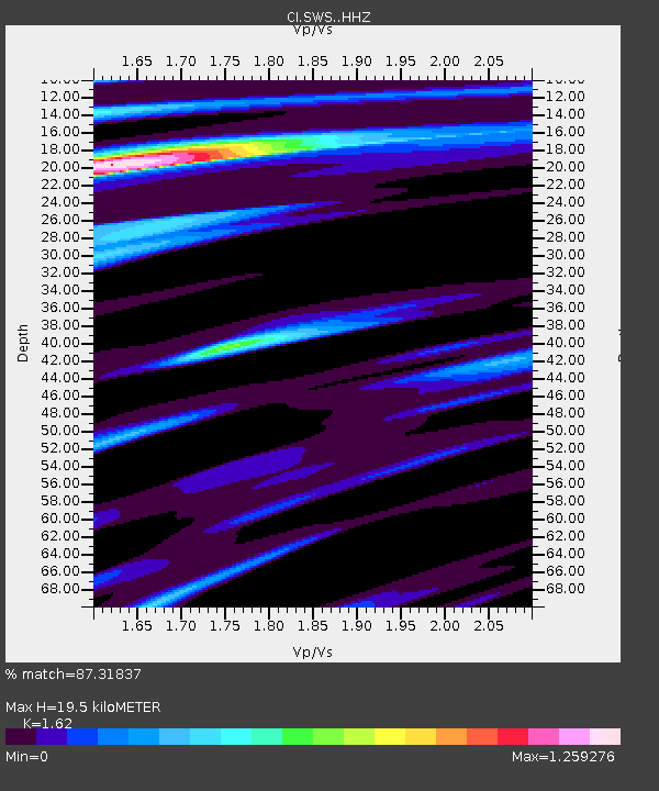
| Estimated Moho Depth: |
19.5 km |
| Estimated Crust Vp/Vs: |
1.62 |
| Assumed Crust Vp: |
6.155 km/s |
| Estimated Crust Vs: |
3.799 km/s |
| Estimated Crust Poisson's Ratio: |
0.19 |
|
| Radial Match: |
87.31837 % |
| Radial Bump: |
400 |
| Transverse Match: |
81.30925 % |
| Transverse Bump: |
385 |
| SOD ConfigId: |
25028951 |
| Insert Time: |
2021-06-14 07:03:28.561 +0000 |
| GWidth: |
2.5 |
| Max Bumps: |
400 |
| Tol: |
0.001 |
|
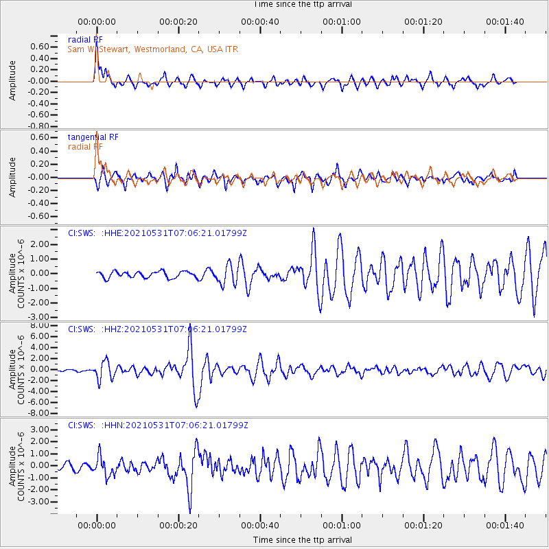
Signal To Noise
| Channel | StoN | STA | LTA |
| CI:SWS: :HHZ:20210531T07:06:21.01799Z | 9.127611 | 1.6314623E-6 | 1.7873924E-7 |
| CI:SWS: :HHN:20210531T07:06:21.01799Z | 3.6267269 | 8.0658106E-7 | 2.2239917E-7 |
| CI:SWS: :HHE:20210531T07:06:21.01799Z | 3.1373203 | 6.8269435E-7 | 2.1760428E-7 |
| Arrivals |
| Ps | 2.1 SECOND |
| PpPs | 7.7 SECOND |
| PsPs/PpSs | 9.8 SECOND |


