KSA XW.KSA - Earthquake Result Viewer
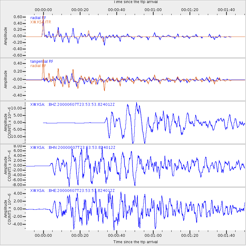
Earthquake location: Southern Sumatra, Indonesia
Earthquake latitude/longitude: -4.6/101.9
Earthquake time(UTC): 2000/06/07 (159) 23:45:26 GMT
Earthquake Depth: 33 km
Earthquake Magnitude: 6.1 MB, 6.7 MS, 6.7 MW, 6.5 MW
Earthquake Catalog/Contributor: WHDF/NEIC
Network: XW Tien Shan Continental Dynamics
Station: KSA XW.KSA
Lat/Lon: 41.54 N/77.93 E
Elevation: 3398 m
Distance: 50.9 deg
Az: 336.845 deg
Baz: 148.523 deg
Ray Param: 0.06770123
Estimated Moho Depth: 60.75 km
Estimated Crust Vp/Vs: 1.84
Assumed Crust Vp: 6.491 km/s
Estimated Crust Vs: 3.523 km/s
Estimated Crust Poisson's Ratio: 0.29
Radial Match: 85.73699 %
Radial Bump: 400
Transverse Match: 83.35843 %
Transverse Bump: 400
SOD ConfigId: 20082
Insert Time: 2010-02-26 15:37:55.348 +0000
GWidth: 2.5
Max Bumps: 400
Tol: 0.001

Signal To Noise

ChannelStoNSTALTA
XW:KSA: :BHN:20000607T23:53:53.824012Z5.4121064.4406107E-78.2049596E-8
XW:KSA: :BHE:20000607T23:53:53.824012Z5.09266663.2398194E-76.361734E-8
XW:KSA: :BHZ:20000607T23:53:53.824012Z17.6539941.1835409E-66.704097E-8
Arrivals
Ps8.3 SECOND
PpPs25 SECOND
PsPs/PpSs33 SECOND