You are here: Home > Network List > GM - US Geological Survey Networks Stations List
> Station NMP02 New Mexico Permian - Site# 02 > Earthquake Result Viewer
NMP02 New Mexico Permian - Site# 02 - Earthquake Result Viewer
| Earthquake location: |
Central Alaska |
| Earthquake latitude/longitude: |
62.4/-148.3 |
| Earthquake time(UTC): |
2021/05/31 (151) 06:59:54 GMT |
| Earthquake Depth: |
44 km |
| Earthquake Magnitude: |
6.1 Mww |
| Earthquake Catalog/Contributor: |
NEIC PDE/ak |
|
| Network: |
GM US Geological Survey Networks |
| Station: |
NMP02 New Mexico Permian - Site# 02 |
| Lat/Lon: |
32.09 N/103.86 W |
| Elevation: |
996 m |
|
| Distance: |
41.4 deg |
| Az: |
116.117 deg |
| Baz: |
330.534 deg |
| Ray Param: |
0.07370471 |
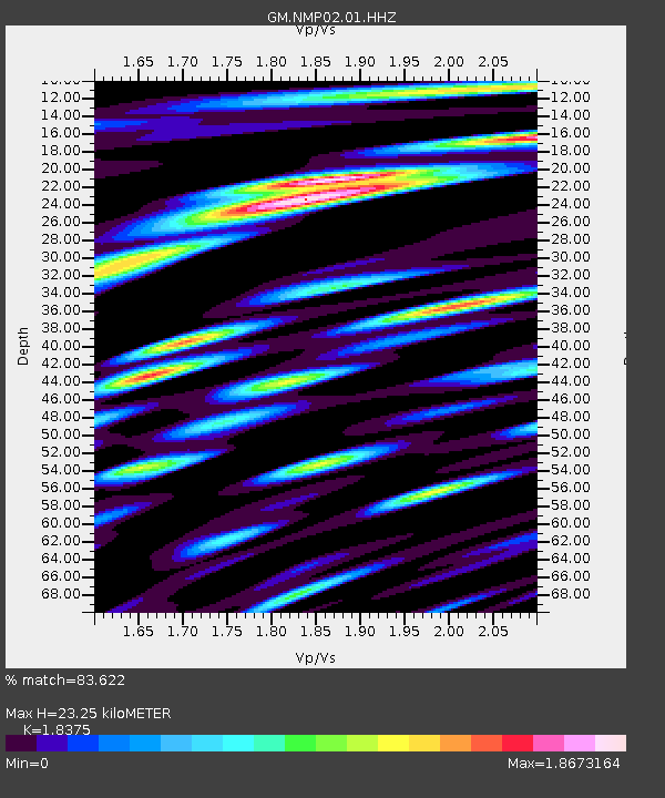
| Estimated Moho Depth: |
23.25 km |
| Estimated Crust Vp/Vs: |
1.84 |
| Assumed Crust Vp: |
6.129 km/s |
| Estimated Crust Vs: |
3.335 km/s |
| Estimated Crust Poisson's Ratio: |
0.29 |
|
| Radial Match: |
83.622 % |
| Radial Bump: |
400 |
| Transverse Match: |
79.59871 % |
| Transverse Bump: |
400 |
| SOD ConfigId: |
25028951 |
| Insert Time: |
2021-06-14 07:07:25.259 +0000 |
| GWidth: |
2.5 |
| Max Bumps: |
400 |
| Tol: |
0.001 |
|

Signal To Noise
| Channel | StoN | STA | LTA |
| GM:NMP02:01:HHZ:20210531T07:07:06.280014Z | 16.198183 | 2.2671027E-6 | 1.3996032E-7 |
| GM:NMP02:01:HHN:20210531T07:07:06.280014Z | 10.556964 | 1.5428402E-6 | 1.4614432E-7 |
| GM:NMP02:01:HHE:20210531T07:07:06.280014Z | 7.39862 | 8.9747704E-7 | 1.213033E-7 |
| Arrivals |
| Ps | 3.4 SECOND |
| PpPs | 10 SECOND |
| PsPs/PpSs | 14 SECOND |


