You are here: Home > Network List > GM - US Geological Survey Networks Stations List
> Station NMP11 New Mexico Permian - Site# W1S1 > Earthquake Result Viewer
NMP11 New Mexico Permian - Site# W1S1 - Earthquake Result Viewer
| Earthquake location: |
Central Alaska |
| Earthquake latitude/longitude: |
62.4/-148.3 |
| Earthquake time(UTC): |
2021/05/31 (151) 06:59:54 GMT |
| Earthquake Depth: |
44 km |
| Earthquake Magnitude: |
6.1 Mww |
| Earthquake Catalog/Contributor: |
NEIC PDE/ak |
|
| Network: |
GM US Geological Survey Networks |
| Station: |
NMP11 New Mexico Permian - Site# W1S1 |
| Lat/Lon: |
32.01 N/103.93 W |
| Elevation: |
883 m |
|
| Distance: |
41.4 deg |
| Az: |
116.257 deg |
| Baz: |
330.602 deg |
| Ray Param: |
0.07367741 |
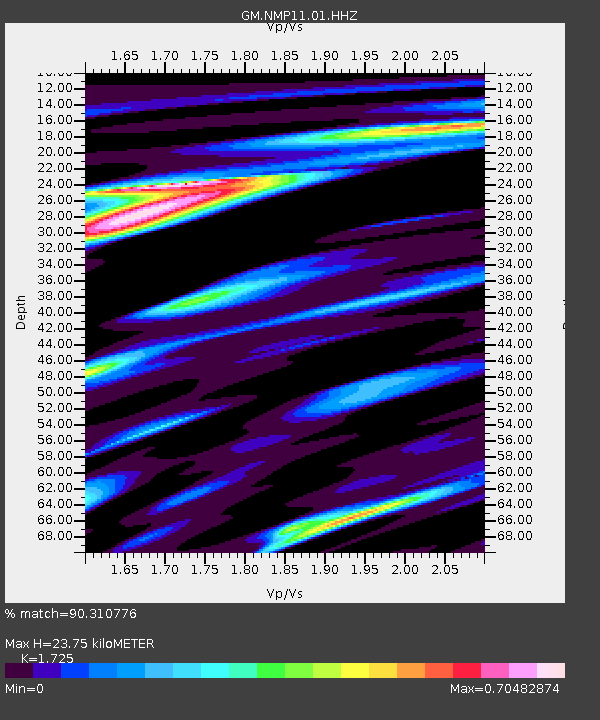
| Estimated Moho Depth: |
23.75 km |
| Estimated Crust Vp/Vs: |
1.73 |
| Assumed Crust Vp: |
6.129 km/s |
| Estimated Crust Vs: |
3.553 km/s |
| Estimated Crust Poisson's Ratio: |
0.25 |
|
| Radial Match: |
90.310776 % |
| Radial Bump: |
400 |
| Transverse Match: |
63.470398 % |
| Transverse Bump: |
400 |
| SOD ConfigId: |
25028951 |
| Insert Time: |
2021-06-14 07:07:27.934 +0000 |
| GWidth: |
2.5 |
| Max Bumps: |
400 |
| Tol: |
0.001 |
|

Signal To Noise
| Channel | StoN | STA | LTA |
| GM:NMP11:01:HHZ:20210531T07:07:06.625015Z | 13.905007 | 1.7838352E-6 | 1.2828724E-7 |
| GM:NMP11:01:HHN:20210531T07:07:06.625015Z | 9.195813 | 8.7157593E-7 | 9.4779644E-8 |
| GM:NMP11:01:HHE:20210531T07:07:06.625015Z | 4.772147 | 3.9652815E-7 | 8.309219E-8 |
| Arrivals |
| Ps | 3.0 SECOND |
| PpPs | 9.9 SECOND |
| PsPs/PpSs | 13 SECOND |


