You are here: Home > Network List > GM - US Geological Survey Networks Stations List
> Station NMP41 New Mexico Permian - Site# W4S1 > Earthquake Result Viewer
NMP41 New Mexico Permian - Site# W4S1 - Earthquake Result Viewer
| Earthquake location: |
Central Alaska |
| Earthquake latitude/longitude: |
62.4/-148.3 |
| Earthquake time(UTC): |
2021/05/31 (151) 06:59:54 GMT |
| Earthquake Depth: |
44 km |
| Earthquake Magnitude: |
6.1 Mww |
| Earthquake Catalog/Contributor: |
NEIC PDE/ak |
|
| Network: |
GM US Geological Survey Networks |
| Station: |
NMP41 New Mexico Permian - Site# W4S1 |
| Lat/Lon: |
32.01 N/103.60 W |
| Elevation: |
960 m |
|
| Distance: |
41.6 deg |
| Az: |
115.884 deg |
| Baz: |
330.5 deg |
| Ray Param: |
0.07358929 |
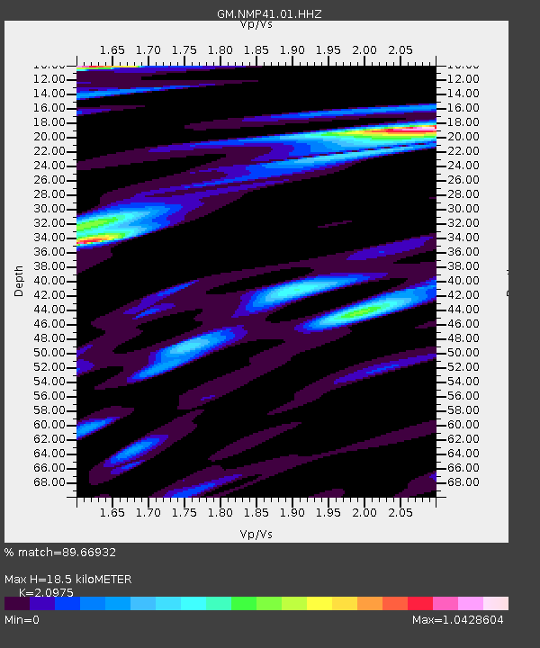
| Estimated Moho Depth: |
18.5 km |
| Estimated Crust Vp/Vs: |
2.10 |
| Assumed Crust Vp: |
6.129 km/s |
| Estimated Crust Vs: |
2.922 km/s |
| Estimated Crust Poisson's Ratio: |
0.35 |
|
| Radial Match: |
89.66932 % |
| Radial Bump: |
400 |
| Transverse Match: |
72.904076 % |
| Transverse Bump: |
400 |
| SOD ConfigId: |
25028951 |
| Insert Time: |
2021-06-14 07:07:34.239 +0000 |
| GWidth: |
2.5 |
| Max Bumps: |
400 |
| Tol: |
0.001 |
|

Signal To Noise
| Channel | StoN | STA | LTA |
| GM:NMP41:01:HHZ:20210531T07:07:07.784988Z | 11.3238945 | 1.8417436E-6 | 1.6264224E-7 |
| GM:NMP41:01:HHN:20210531T07:07:07.784988Z | 9.52112 | 1.0387195E-6 | 1.09096355E-7 |
| GM:NMP41:01:HHE:20210531T07:07:07.784988Z | 4.270888 | 4.4139804E-7 | 1.0335042E-7 |
| Arrivals |
| Ps | 3.5 SECOND |
| PpPs | 8.9 SECOND |
| PsPs/PpSs | 12 SECOND |


