You are here: Home > Network List > GM - US Geological Survey Networks Stations List
> Station NMP53 New Mexico Permian - Site# W5S3 > Earthquake Result Viewer
NMP53 New Mexico Permian - Site# W5S3 - Earthquake Result Viewer
| Earthquake location: |
Central Alaska |
| Earthquake latitude/longitude: |
62.4/-148.3 |
| Earthquake time(UTC): |
2021/05/31 (151) 06:59:54 GMT |
| Earthquake Depth: |
44 km |
| Earthquake Magnitude: |
6.1 Mww |
| Earthquake Catalog/Contributor: |
NEIC PDE/ak |
|
| Network: |
GM US Geological Survey Networks |
| Station: |
NMP53 New Mexico Permian - Site# W5S3 |
| Lat/Lon: |
32.18 N/103.43 W |
| Elevation: |
1037 m |
|
| Distance: |
41.5 deg |
| Az: |
115.573 deg |
| Baz: |
330.354 deg |
| Ray Param: |
0.07363898 |
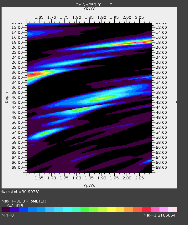
| Estimated Moho Depth: |
30.0 km |
| Estimated Crust Vp/Vs: |
1.62 |
| Assumed Crust Vp: |
6.129 km/s |
| Estimated Crust Vs: |
3.795 km/s |
| Estimated Crust Poisson's Ratio: |
0.19 |
|
| Radial Match: |
90.99751 % |
| Radial Bump: |
400 |
| Transverse Match: |
43.844154 % |
| Transverse Bump: |
400 |
| SOD ConfigId: |
25028951 |
| Insert Time: |
2021-06-14 07:07:37.364 +0000 |
| GWidth: |
2.5 |
| Max Bumps: |
400 |
| Tol: |
0.001 |
|

Signal To Noise
| Channel | StoN | STA | LTA |
| GM:NMP53:01:HHZ:20210531T07:07:07.134994Z | 11.082471 | 2.2237891E-6 | 2.0065823E-7 |
| GM:NMP53:01:HHN:20210531T07:07:07.134994Z | 6.4191146 | 1.0748648E-6 | 1.6744751E-7 |
| GM:NMP53:01:HHE:20210531T07:07:07.134994Z | 1.8536012 | 4.7199865E-7 | 2.5463873E-7 |
| Arrivals |
| Ps | 3.2 SECOND |
| PpPs | 12 SECOND |
| PsPs/PpSs | 15 SECOND |


