You are here: Home > Network List > GS - US Geological Survey Networks Stations List
> Station OK051 E0350 and S34600 roads, Ralston OK > Earthquake Result Viewer
OK051 E0350 and S34600 roads, Ralston OK - Earthquake Result Viewer

| Earthquake location: |
Central Alaska |
| Earthquake latitude/longitude: |
62.4/-148.3 |
| Earthquake time(UTC): |
2021/05/31 (151) 06:59:54 GMT |
| Earthquake Depth: |
44 km |
| Earthquake Magnitude: |
6.1 Mww |
| Earthquake Catalog/Contributor: |
NEIC PDE/ak |
|
| Network: |
GS US Geological Survey Networks |
| Station: |
OK051 E0350 and S34600 roads, Ralston OK |
| Lat/Lon: |
36.50 N/96.84 W |
| Elevation: |
263 m |
|
| Distance: |
40.7 deg |
| Az: |
105.054 deg |
| Baz: |
326.128 deg |
| Ray Param: |
0.0741344 |
| Estimated Moho Depth: |
50.25 km |
| Estimated Crust Vp/Vs: |
1.67 |
| Assumed Crust Vp: |
6.483 km/s |
| Estimated Crust Vs: |
3.882 km/s |
| Estimated Crust Poisson's Ratio: |
0.22 |
|
| Radial Match: |
88.70319 % |
| Radial Bump: |
281 |
| Transverse Match: |
73.61336 % |
| Transverse Bump: |
400 |
| SOD ConfigId: |
25028951 |
| Insert Time: |
2021-06-14 07:08:03.894 +0000 |
| GWidth: |
2.5 |
| Max Bumps: |
400 |
| Tol: |
0.001 |
|
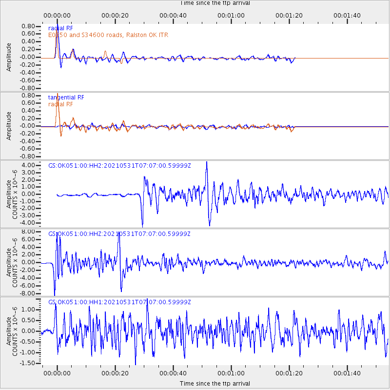
Signal To Noise
| Channel | StoN | STA | LTA |
| GS:OK051:00:HHZ:20210531T07:07:00.59999Z | 40.783974 | 3.7325333E-6 | 9.151961E-8 |
| GS:OK051:00:HH1:20210531T07:07:00.59999Z | 5.6993 | 6.1183187E-7 | 1.0735212E-7 |
| GS:OK051:00:HH2:20210531T07:07:00.59999Z | 16.1454 | 1.79404E-6 | 1.1111773E-7 |
| Arrivals |
| Ps | 5.6 SECOND |
| PpPs | 19 SECOND |
| PsPs/PpSs | 25 SECOND |


