You are here: Home > Network List > IU - Global Seismograph Network (GSN - IRIS/USGS) Stations List
> Station PMG Port Moresby, New Guinea > Earthquake Result Viewer
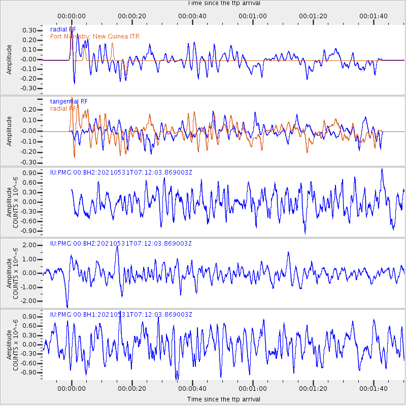
PMG Port Moresby, New Guinea - Earthquake Result Viewer
*The percent match for this event was below the threshold and hence no stack was calculated.
| Earthquake location: |
Central Alaska |
| Earthquake latitude/longitude: |
62.4/-148.3 |
| Earthquake time(UTC): |
2021/05/31 (151) 06:59:54 GMT |
| Earthquake Depth: |
44 km |
| Earthquake Magnitude: |
6.1 Mww |
| Earthquake Catalog/Contributor: |
NEIC PDE/ak |
|
| Network: |
IU Global Seismograph Network (GSN - IRIS/USGS) |
| Station: |
PMG Port Moresby, New Guinea |
| Lat/Lon: |
9.40 S/147.16 E |
| Elevation: |
90 m |
|
| Distance: |
87.0 deg |
| Az: |
243.191 deg |
| Baz: |
24.873 deg |
| Ray Param: |
$rayparam |
*The percent match for this event was below the threshold and hence was not used in the summary stack. |
|
| Radial Match: |
70.567406 % |
| Radial Bump: |
400 |
| Transverse Match: |
62.362022 % |
| Transverse Bump: |
400 |
| SOD ConfigId: |
25028951 |
| Insert Time: |
2021-06-14 07:10:00.404 +0000 |
| GWidth: |
2.5 |
| Max Bumps: |
400 |
| Tol: |
0.001 |
|
Signal To Noise
| Channel | StoN | STA | LTA |
| IU:PMG:00:BHZ:20210531T07:12:03.869003Z | 2.5336652 | 6.42637E-7 | 2.5363926E-7 |
| IU:PMG:00:BH1:20210531T07:12:03.869003Z | 1.9545037 | 4.585037E-7 | 2.345883E-7 |
| IU:PMG:00:BH2:20210531T07:12:03.869003Z | 1.5828462 | 4.1640783E-7 | 2.6307535E-7 |
| Arrivals |
| Ps | |
| PpPs | |
| PsPs/PpSs | |


