You are here: Home > Network List > IU - Global Seismograph Network (GSN - IRIS/USGS) Stations List
> Station NWAO Narrogin, Australia > Earthquake Result Viewer
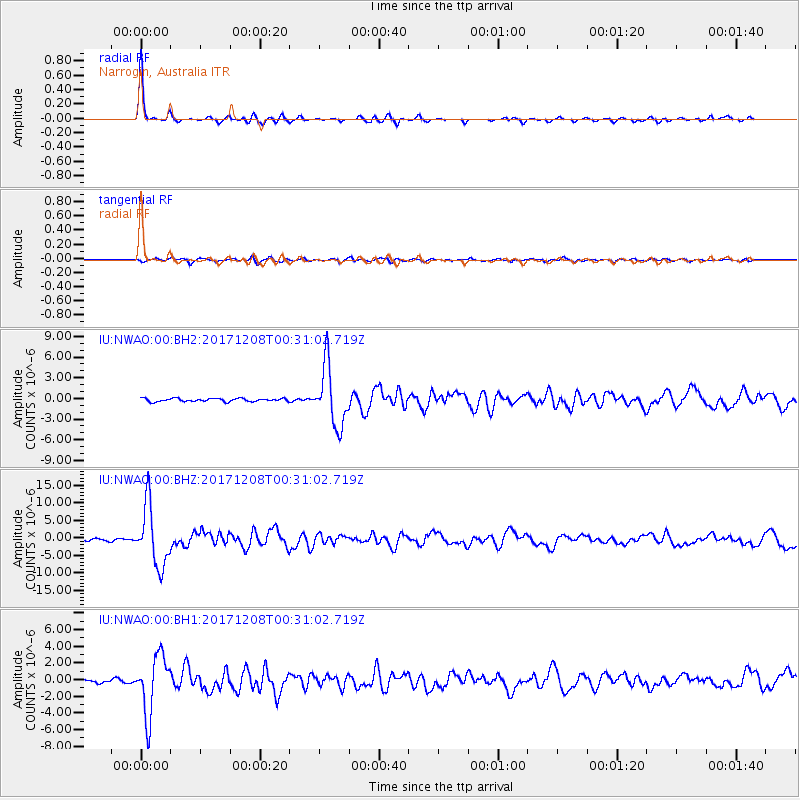
NWAO Narrogin, Australia - Earthquake Result Viewer

| Earthquake location: |
W. Caroline Islands, Micronesia |
| Earthquake latitude/longitude: |
10.1/140.2 |
| Earthquake time(UTC): |
2017/12/08 (342) 00:22:53 GMT |
| Earthquake Depth: |
7.5 km |
| Earthquake Magnitude: |
6.5 mww |
| Earthquake Catalog/Contributor: |
NEIC PDE/us |
|
| Network: |
IU Global Seismograph Network (GSN - IRIS/USGS) |
| Station: |
NWAO Narrogin, Australia |
| Lat/Lon: |
32.93 S/117.24 E |
| Elevation: |
380 m |
|
| Distance: |
48.1 deg |
| Az: |
206.156 deg |
| Baz: |
31.069 deg |
| Ray Param: |
0.06957476 |
| Estimated Moho Depth: |
38.25 km |
| Estimated Crust Vp/Vs: |
1.80 |
| Assumed Crust Vp: |
6.419 km/s |
| Estimated Crust Vs: |
3.576 km/s |
| Estimated Crust Poisson's Ratio: |
0.27 |
|
| Radial Match: |
95.31038 % |
| Radial Bump: |
245 |
| Transverse Match: |
76.627686 % |
| Transverse Bump: |
400 |
| SOD ConfigId: |
2429771 |
| Insert Time: |
2017-12-22 00:24:46.468 +0000 |
| GWidth: |
2.5 |
| Max Bumps: |
400 |
| Tol: |
0.001 |
|
Signal To Noise
| Channel | StoN | STA | LTA |
| IU:NWAO:00:BHZ:20171208T00:31:02.719Z | 27.125572 | 8.542652E-6 | 3.1492985E-7 |
| IU:NWAO:00:BH1:20171208T00:31:02.719Z | 19.548683 | 3.5011183E-6 | 1.7909738E-7 |
| IU:NWAO:00:BH2:20171208T00:31:02.719Z | 19.129292 | 4.2992965E-6 | 2.2474937E-7 |
| Arrivals |
| Ps | 5.0 SECOND |
| PpPs | 16 SECOND |
| PsPs/PpSs | 21 SECOND |


