You are here: Home > Network List > MX - Mexican National Seismic Network Stations List
> Station MOIG Morelia, Mich, MX > Earthquake Result Viewer
MOIG Morelia, Mich, MX - Earthquake Result Viewer
| Earthquake location: |
Central Alaska |
| Earthquake latitude/longitude: |
62.4/-148.3 |
| Earthquake time(UTC): |
2021/05/31 (151) 06:59:54 GMT |
| Earthquake Depth: |
44 km |
| Earthquake Magnitude: |
6.1 Mww |
| Earthquake Catalog/Contributor: |
NEIC PDE/ak |
|
| Network: |
MX Mexican National Seismic Network |
| Station: |
MOIG Morelia, Mich, MX |
| Lat/Lon: |
19.65 N/101.23 W |
| Elevation: |
2000 m |
|
| Distance: |
53.5 deg |
| Az: |
120.939 deg |
| Baz: |
334.964 deg |
| Ray Param: |
0.06595734 |
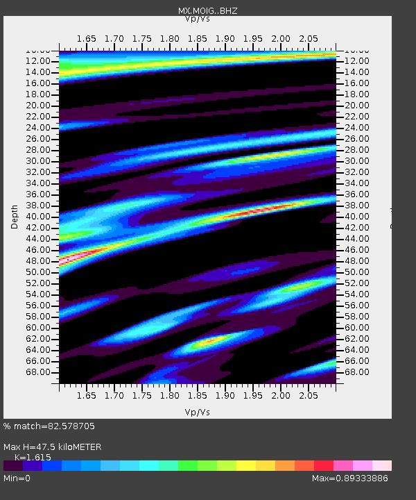
| Estimated Moho Depth: |
47.5 km |
| Estimated Crust Vp/Vs: |
1.62 |
| Assumed Crust Vp: |
6.566 km/s |
| Estimated Crust Vs: |
4.066 km/s |
| Estimated Crust Poisson's Ratio: |
0.19 |
|
| Radial Match: |
82.578705 % |
| Radial Bump: |
400 |
| Transverse Match: |
76.846634 % |
| Transverse Bump: |
400 |
| SOD ConfigId: |
25028951 |
| Insert Time: |
2021-06-14 07:12:11.497 +0000 |
| GWidth: |
2.5 |
| Max Bumps: |
400 |
| Tol: |
0.001 |
|

Signal To Noise
| Channel | StoN | STA | LTA |
| MX:MOIG: :BHZ:20210531T07:08:40.194992Z | 8.458185 | 2.1534813E-6 | 2.5460324E-7 |
| MX:MOIG: :BHN:20210531T07:08:40.194992Z | 4.605466 | 1.1047337E-6 | 2.3987448E-7 |
| MX:MOIG: :BHE:20210531T07:08:40.194992Z | 1.8101082 | 4.1682296E-7 | 2.3027516E-7 |
| Arrivals |
| Ps | 4.7 SECOND |
| PpPs | 18 SECOND |
| PsPs/PpSs | 23 SECOND |


