You are here: Home > Network List > N4 - Central and EAstern US Network Stations List
> Station I40B Norwalk, WI, USA > Earthquake Result Viewer
I40B Norwalk, WI, USA - Earthquake Result Viewer
| Earthquake location: |
Central Alaska |
| Earthquake latitude/longitude: |
62.4/-148.3 |
| Earthquake time(UTC): |
2021/05/31 (151) 06:59:54 GMT |
| Earthquake Depth: |
44 km |
| Earthquake Magnitude: |
6.1 Mww |
| Earthquake Catalog/Contributor: |
NEIC PDE/ak |
|
| Network: |
N4 Central and EAstern US Network |
| Station: |
I40B Norwalk, WI, USA |
| Lat/Lon: |
43.89 N/90.62 W |
| Elevation: |
419 m |
|
| Distance: |
37.7 deg |
| Az: |
92.002 deg |
| Baz: |
319.999 deg |
| Ray Param: |
0.07590578 |
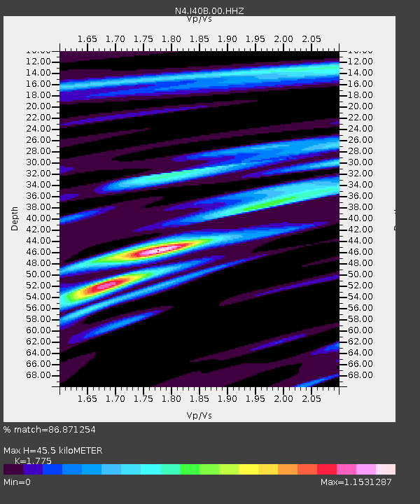
| Estimated Moho Depth: |
45.5 km |
| Estimated Crust Vp/Vs: |
1.77 |
| Assumed Crust Vp: |
6.53 km/s |
| Estimated Crust Vs: |
3.679 km/s |
| Estimated Crust Poisson's Ratio: |
0.27 |
|
| Radial Match: |
86.871254 % |
| Radial Bump: |
400 |
| Transverse Match: |
65.516754 % |
| Transverse Bump: |
400 |
| SOD ConfigId: |
25028951 |
| Insert Time: |
2021-06-14 07:12:56.296 +0000 |
| GWidth: |
2.5 |
| Max Bumps: |
400 |
| Tol: |
0.001 |
|

Signal To Noise
| Channel | StoN | STA | LTA |
| N4:I40B:00:HHZ:20210531T07:06:35.229995Z | 9.20685 | 2.9204623E-6 | 3.1720538E-7 |
| N4:I40B:00:HH1:20210531T07:06:35.229995Z | 5.7030325 | 1.411044E-6 | 2.4741993E-7 |
| N4:I40B:00:HH2:20210531T07:06:35.229995Z | 5.7542267 | 1.2810533E-6 | 2.2262823E-7 |
| Arrivals |
| Ps | 5.8 SECOND |
| PpPs | 18 SECOND |
| PsPs/PpSs | 24 SECOND |


