You are here: Home > Network List > N4 - Central and EAstern US Network Stations List
> Station J47A Sunmer, MI, USA > Earthquake Result Viewer
J47A Sunmer, MI, USA - Earthquake Result Viewer
| Earthquake location: |
Central Alaska |
| Earthquake latitude/longitude: |
62.4/-148.3 |
| Earthquake time(UTC): |
2021/05/31 (151) 06:59:54 GMT |
| Earthquake Depth: |
44 km |
| Earthquake Magnitude: |
6.1 Mww |
| Earthquake Catalog/Contributor: |
NEIC PDE/ak |
|
| Network: |
N4 Central and EAstern US Network |
| Station: |
J47A Sunmer, MI, USA |
| Lat/Lon: |
43.24 N/84.82 W |
| Elevation: |
236 m |
|
| Distance: |
40.9 deg |
| Az: |
87.543 deg |
| Baz: |
320.526 deg |
| Ray Param: |
0.074041575 |
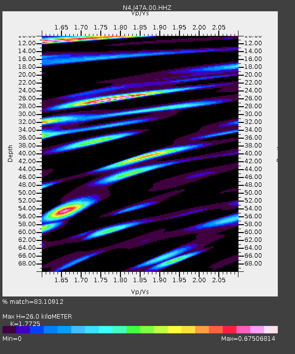
| Estimated Moho Depth: |
26.0 km |
| Estimated Crust Vp/Vs: |
1.77 |
| Assumed Crust Vp: |
6.483 km/s |
| Estimated Crust Vs: |
3.657 km/s |
| Estimated Crust Poisson's Ratio: |
0.27 |
|
| Radial Match: |
83.10912 % |
| Radial Bump: |
400 |
| Transverse Match: |
64.795815 % |
| Transverse Bump: |
400 |
| SOD ConfigId: |
25028951 |
| Insert Time: |
2021-06-14 07:13:02.146 +0000 |
| GWidth: |
2.5 |
| Max Bumps: |
400 |
| Tol: |
0.001 |
|

Signal To Noise
| Channel | StoN | STA | LTA |
| N4:J47A:00:HHZ:20210531T07:07:01.84999Z | 8.01273 | 2.4296364E-6 | 3.0322207E-7 |
| N4:J47A:00:HH1:20210531T07:07:01.84999Z | 6.8991594 | 1.4585419E-6 | 2.1140863E-7 |
| N4:J47A:00:HH2:20210531T07:07:01.84999Z | 5.5135694 | 1.0976565E-6 | 1.9908275E-7 |
| Arrivals |
| Ps | 3.3 SECOND |
| PpPs | 10 SECOND |
| PsPs/PpSs | 14 SECOND |


