You are here: Home > Network List > N4 - Central and EAstern US Network Stations List
> Station L42A Oliver, Polo, IL, USA > Earthquake Result Viewer
L42A Oliver, Polo, IL, USA - Earthquake Result Viewer
| Earthquake location: |
Central Alaska |
| Earthquake latitude/longitude: |
62.4/-148.3 |
| Earthquake time(UTC): |
2021/05/31 (151) 06:59:54 GMT |
| Earthquake Depth: |
44 km |
| Earthquake Magnitude: |
6.1 Mww |
| Earthquake Catalog/Contributor: |
NEIC PDE/ak |
|
| Network: |
N4 Central and EAstern US Network |
| Station: |
L42A Oliver, Polo, IL, USA |
| Lat/Lon: |
42.00 N/89.67 W |
| Elevation: |
257 m |
|
| Distance: |
39.6 deg |
| Az: |
93.05 deg |
| Baz: |
321.463 deg |
| Ray Param: |
0.07480492 |
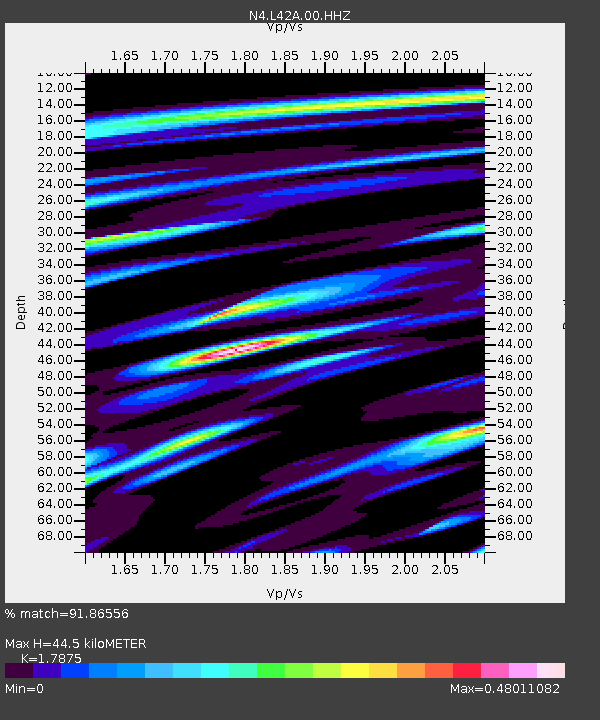
| Estimated Moho Depth: |
44.5 km |
| Estimated Crust Vp/Vs: |
1.79 |
| Assumed Crust Vp: |
6.571 km/s |
| Estimated Crust Vs: |
3.676 km/s |
| Estimated Crust Poisson's Ratio: |
0.27 |
|
| Radial Match: |
91.86556 % |
| Radial Bump: |
387 |
| Transverse Match: |
63.129444 % |
| Transverse Bump: |
400 |
| SOD ConfigId: |
25028951 |
| Insert Time: |
2021-06-14 07:13:22.101 +0000 |
| GWidth: |
2.5 |
| Max Bumps: |
400 |
| Tol: |
0.001 |
|

Signal To Noise
| Channel | StoN | STA | LTA |
| N4:L42A:00:HHZ:20210531T07:06:51.159011Z | 15.095627 | 2.3310224E-6 | 1.5441707E-7 |
| N4:L42A:00:HH1:20210531T07:06:51.159011Z | 7.9162817 | 1.1865698E-6 | 1.4988979E-7 |
| N4:L42A:00:HH2:20210531T07:06:51.159011Z | 5.526912 | 1.0553618E-6 | 1.9094963E-7 |
| Arrivals |
| Ps | 5.7 SECOND |
| PpPs | 18 SECOND |
| PsPs/PpSs | 23 SECOND |


