You are here: Home > Network List > ND - New CaleDonia Broadband Seismic Network Stations List
> Station PINNC Pines island, New Caledonia > Earthquake Result Viewer
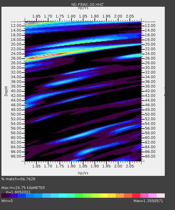
PINNC Pines island, New Caledonia - Earthquake Result Viewer
| Earthquake location: |
W. Caroline Islands, Micronesia |
| Earthquake latitude/longitude: |
10.1/140.2 |
| Earthquake time(UTC): |
2017/12/08 (342) 00:22:53 GMT |
| Earthquake Depth: |
7.5 km |
| Earthquake Magnitude: |
6.5 mww |
| Earthquake Catalog/Contributor: |
NEIC PDE/us |
|
| Network: |
ND New CaleDonia Broadband Seismic Network |
| Station: |
PINNC Pines island, New Caledonia |
| Lat/Lon: |
22.61 S/167.45 E |
| Elevation: |
21 m |
|
| Distance: |
42.1 deg |
| Az: |
140.885 deg |
| Baz: |
317.763 deg |
| Ray Param: |
0.07337621 |
| Estimated Moho Depth: |
24.75 km |
| Estimated Crust Vp/Vs: |
1.69 |
| Assumed Crust Vp: |
5.14 km/s |
| Estimated Crust Vs: |
3.05 km/s |
| Estimated Crust Poisson's Ratio: |
0.23 |
|
| Radial Match: |
86.7629 % |
| Radial Bump: |
400 |
| Transverse Match: |
78.20407 % |
| Transverse Bump: |
400 |
| SOD ConfigId: |
2429771 |
| Insert Time: |
2017-12-22 00:25:29.288 +0000 |
| GWidth: |
2.5 |
| Max Bumps: |
400 |
| Tol: |
0.001 |
|

Signal To Noise
| Channel | StoN | STA | LTA |
| ND:PINNC:00:HHZ:20171208T00:30:15.031012Z | 4.083514 | 2.284076E-6 | 5.593408E-7 |
| ND:PINNC:00:HHN:20171208T00:30:15.031012Z | 1.8386683 | 8.2814176E-7 | 4.5040304E-7 |
| ND:PINNC:00:HHE:20171208T00:30:15.031012Z | 2.2954183 | 9.1449357E-7 | 3.9839955E-7 |
| Arrivals |
| Ps | 3.4 SECOND |
| PpPs | 12 SECOND |
| PsPs/PpSs | 16 SECOND |


