You are here: Home > Network List > N4 - Central and EAstern US Network Stations List
> Station O20A White River City, CO, USA > Earthquake Result Viewer
O20A White River City, CO, USA - Earthquake Result Viewer
| Earthquake location: |
Central Alaska |
| Earthquake latitude/longitude: |
62.4/-148.3 |
| Earthquake time(UTC): |
2021/05/31 (151) 06:59:54 GMT |
| Earthquake Depth: |
44 km |
| Earthquake Magnitude: |
6.1 Mww |
| Earthquake Catalog/Contributor: |
NEIC PDE/ak |
|
| Network: |
N4 Central and EAstern US Network |
| Station: |
O20A White River City, CO, USA |
| Lat/Lon: |
40.13 N/108.24 W |
| Elevation: |
1915 m |
|
| Distance: |
32.7 deg |
| Az: |
114.176 deg |
| Baz: |
326.403 deg |
| Ray Param: |
0.07845638 |
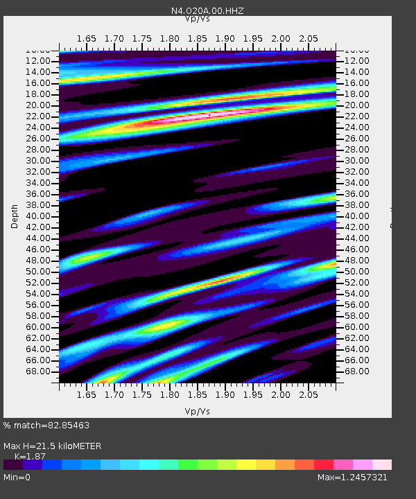
| Estimated Moho Depth: |
21.5 km |
| Estimated Crust Vp/Vs: |
1.87 |
| Assumed Crust Vp: |
6.207 km/s |
| Estimated Crust Vs: |
3.319 km/s |
| Estimated Crust Poisson's Ratio: |
0.30 |
|
| Radial Match: |
82.85463 % |
| Radial Bump: |
400 |
| Transverse Match: |
67.08736 % |
| Transverse Bump: |
400 |
| SOD ConfigId: |
25028951 |
| Insert Time: |
2021-06-14 07:13:49.558 +0000 |
| GWidth: |
2.5 |
| Max Bumps: |
400 |
| Tol: |
0.001 |
|

Signal To Noise
| Channel | StoN | STA | LTA |
| N4:O20A:00:HHZ:20210531T07:05:52.680008Z | 18.268991 | 2.0379234E-6 | 1.1155096E-7 |
| N4:O20A:00:HH1:20210531T07:05:52.680008Z | 6.088559 | 7.928648E-7 | 1.3022208E-7 |
| N4:O20A:00:HH2:20210531T07:05:52.680008Z | 8.89386 | 1.0361074E-6 | 1.1649692E-7 |
| Arrivals |
| Ps | 3.2 SECOND |
| PpPs | 9.3 SECOND |
| PsPs/PpSs | 13 SECOND |


