You are here: Home > Network List > N4 - Central and EAstern US Network Stations List
> Station P43A Skaggs, Pawnee, IL, USA > Earthquake Result Viewer
P43A Skaggs, Pawnee, IL, USA - Earthquake Result Viewer
| Earthquake location: |
Central Alaska |
| Earthquake latitude/longitude: |
62.4/-148.3 |
| Earthquake time(UTC): |
2021/05/31 (151) 06:59:54 GMT |
| Earthquake Depth: |
44 km |
| Earthquake Magnitude: |
6.1 Mww |
| Earthquake Catalog/Contributor: |
NEIC PDE/ak |
|
| Network: |
N4 Central and EAstern US Network |
| Station: |
P43A Skaggs, Pawnee, IL, USA |
| Lat/Lon: |
39.64 N/89.52 W |
| Elevation: |
176 m |
|
| Distance: |
41.5 deg |
| Az: |
95.136 deg |
| Baz: |
323.144 deg |
| Ray Param: |
0.07364074 |
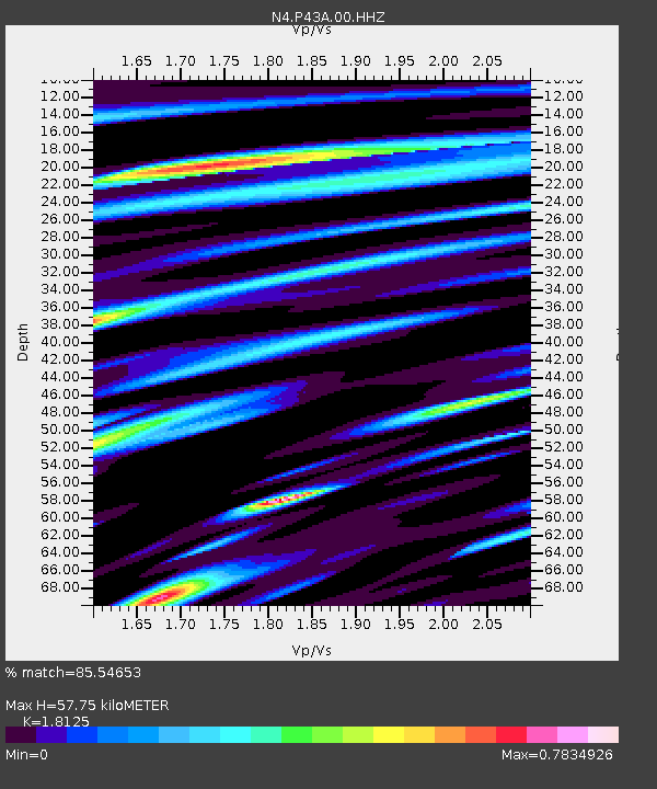
| Estimated Moho Depth: |
57.75 km |
| Estimated Crust Vp/Vs: |
1.81 |
| Assumed Crust Vp: |
6.444 km/s |
| Estimated Crust Vs: |
3.555 km/s |
| Estimated Crust Poisson's Ratio: |
0.28 |
|
| Radial Match: |
85.54653 % |
| Radial Bump: |
400 |
| Transverse Match: |
72.76051 % |
| Transverse Bump: |
400 |
| SOD ConfigId: |
25028951 |
| Insert Time: |
2021-06-14 07:13:57.909 +0000 |
| GWidth: |
2.5 |
| Max Bumps: |
400 |
| Tol: |
0.001 |
|

Signal To Noise
| Channel | StoN | STA | LTA |
| N4:P43A:00:HHZ:20210531T07:07:07.110Z | 9.977107 | 1.446403E-6 | 1.4497218E-7 |
| N4:P43A:00:HH1:20210531T07:07:07.110Z | 9.310893 | 8.780802E-7 | 9.430676E-8 |
| N4:P43A:00:HH2:20210531T07:07:07.110Z | 4.4803395 | 5.3440294E-7 | 1.1927733E-7 |
| Arrivals |
| Ps | 7.8 SECOND |
| PpPs | 24 SECOND |
| PsPs/PpSs | 31 SECOND |


