You are here: Home > Network List > N4 - Central and EAstern US Network Stations List
> Station W52A Murphy, NC, USA > Earthquake Result Viewer
W52A Murphy, NC, USA - Earthquake Result Viewer
| Earthquake location: |
Central Alaska |
| Earthquake latitude/longitude: |
62.4/-148.3 |
| Earthquake time(UTC): |
2021/05/31 (151) 06:59:54 GMT |
| Earthquake Depth: |
44 km |
| Earthquake Magnitude: |
6.1 Mww |
| Earthquake Catalog/Contributor: |
NEIC PDE/ak |
|
| Network: |
N4 Central and EAstern US Network |
| Station: |
W52A Murphy, NC, USA |
| Lat/Lon: |
35.09 N/83.93 W |
| Elevation: |
519 m |
|
| Distance: |
47.8 deg |
| Az: |
93.746 deg |
| Baz: |
325.538 deg |
| Ray Param: |
0.06968352 |
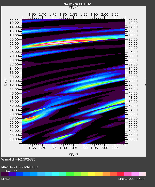
| Estimated Moho Depth: |
21.5 km |
| Estimated Crust Vp/Vs: |
1.77 |
| Assumed Crust Vp: |
6.35 km/s |
| Estimated Crust Vs: |
3.588 km/s |
| Estimated Crust Poisson's Ratio: |
0.27 |
|
| Radial Match: |
92.392685 % |
| Radial Bump: |
338 |
| Transverse Match: |
73.12455 % |
| Transverse Bump: |
400 |
| SOD ConfigId: |
25028951 |
| Insert Time: |
2021-06-14 07:14:58.842 +0000 |
| GWidth: |
2.5 |
| Max Bumps: |
400 |
| Tol: |
0.001 |
|

Signal To Noise
| Channel | StoN | STA | LTA |
| N4:W52A:00:HHZ:20210531T07:07:57.09999Z | 11.882749 | 1.878992E-6 | 1.5812772E-7 |
| N4:W52A:00:HH1:20210531T07:07:57.09999Z | 7.3802156 | 9.3039836E-7 | 1.2606655E-7 |
| N4:W52A:00:HH2:20210531T07:07:57.09999Z | 8.822545 | 7.838442E-7 | 8.884559E-8 |
| Arrivals |
| Ps | 2.8 SECOND |
| PpPs | 8.8 SECOND |
| PsPs/PpSs | 12 SECOND |


