You are here: Home > Network List > N4 - Central and EAstern US Network Stations List
> Station X48A Hartselle, AL, USA > Earthquake Result Viewer
X48A Hartselle, AL, USA - Earthquake Result Viewer
| Earthquake location: |
Central Alaska |
| Earthquake latitude/longitude: |
62.4/-148.3 |
| Earthquake time(UTC): |
2021/05/31 (151) 06:59:54 GMT |
| Earthquake Depth: |
44 km |
| Earthquake Magnitude: |
6.1 Mww |
| Earthquake Catalog/Contributor: |
NEIC PDE/ak |
|
| Network: |
N4 Central and EAstern US Network |
| Station: |
X48A Hartselle, AL, USA |
| Lat/Lon: |
34.45 N/87.05 W |
| Elevation: |
180 m |
|
| Distance: |
46.9 deg |
| Az: |
97.122 deg |
| Baz: |
326.056 deg |
| Ray Param: |
0.070263006 |
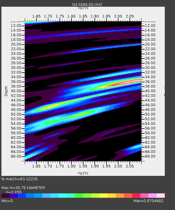
| Estimated Moho Depth: |
35.75 km |
| Estimated Crust Vp/Vs: |
2.06 |
| Assumed Crust Vp: |
6.476 km/s |
| Estimated Crust Vs: |
3.151 km/s |
| Estimated Crust Poisson's Ratio: |
0.34 |
|
| Radial Match: |
93.32235 % |
| Radial Bump: |
339 |
| Transverse Match: |
79.91403 % |
| Transverse Bump: |
400 |
| SOD ConfigId: |
25028951 |
| Insert Time: |
2021-06-14 07:15:02.710 +0000 |
| GWidth: |
2.5 |
| Max Bumps: |
400 |
| Tol: |
0.001 |
|

Signal To Noise
| Channel | StoN | STA | LTA |
| N4:X48A:00:HHZ:20210531T07:07:50.009994Z | 22.169317 | 2.0209663E-6 | 9.116052E-8 |
| N4:X48A:00:HH1:20210531T07:07:50.009994Z | 7.166647 | 8.907557E-7 | 1.2429184E-7 |
| N4:X48A:00:HH2:20210531T07:07:50.009994Z | 10.945655 | 7.999944E-7 | 7.3087854E-8 |
| Arrivals |
| Ps | 6.1 SECOND |
| PpPs | 16 SECOND |
| PsPs/PpSs | 22 SECOND |


