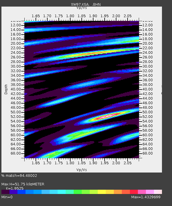
KSA XW.KSA - Earthquake Result Viewer
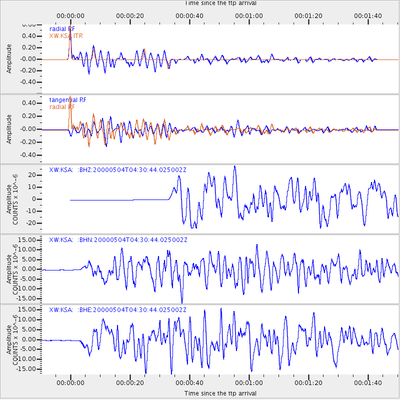
Earthquake location: Sulawesi, Indonesia
Earthquake latitude/longitude: -1.1/123.6
Earthquake time(UTC): 2000/05/04 (125) 04:21:16 GMT
Earthquake Depth: 26 km
Earthquake Magnitude: 6.7 MB, 7.5 MS, 7.6 MW, 7.5 ME
Earthquake Catalog/Contributor: WHDF/NEIC
Network: XW Tien Shan Continental Dynamics
Station: KSA XW.KSA
Lat/Lon: 41.54 N/77.93 E
Elevation: 3398 m
Distance: 59.2 deg
Az: 321.326 deg
Baz: 123.665 deg
Ray Param: 0.06230585
Estimated Moho Depth: 51.75 km
Estimated Crust Vp/Vs: 1.95
Assumed Crust Vp: 6.491 km/s
Estimated Crust Vs: 3.324 km/s
Estimated Crust Poisson's Ratio: 0.32
Radial Match: 94.48002 %
Radial Bump: 400
Transverse Match: 85.86713 %
Transverse Bump: 400
SOD ConfigId: 20082
Insert Time: 2010-02-26 15:38:11.212 +0000
GWidth: 2.5
Max Bumps: 400
Tol: 0.001

Signal To Noise

ChannelStoNSTALTA
XW:KSA: :BHN:20000504T04:30:44.025002Z20.3350526.944861E-73.415217E-8
XW:KSA: :BHE:20000504T04:30:44.025002Z28.920061.2068901E-64.1731937E-8
XW:KSA: :BHZ:20000504T04:30:44.025002Z44.045773.435771E-67.800457E-8
Arrivals
Ps7.9 SECOND
PpPs23 SECOND
PsPs/PpSs30 SECOND