You are here: Home > Network List > NM - Cooperative New Madrid Seismic Network Stations List
> Station FFIL Fairfield, IL > Earthquake Result Viewer
FFIL Fairfield, IL - Earthquake Result Viewer
| Earthquake location: |
Central Alaska |
| Earthquake latitude/longitude: |
62.4/-148.3 |
| Earthquake time(UTC): |
2021/05/31 (151) 06:59:54 GMT |
| Earthquake Depth: |
44 km |
| Earthquake Magnitude: |
6.1 Mww |
| Earthquake Catalog/Contributor: |
NEIC PDE/ak |
|
| Network: |
NM Cooperative New Madrid Seismic Network |
| Station: |
FFIL Fairfield, IL |
| Lat/Lon: |
38.38 N/88.39 W |
| Elevation: |
446 m |
|
| Distance: |
43.0 deg |
| Az: |
95.194 deg |
| Baz: |
323.896 deg |
| Ray Param: |
0.07269985 |
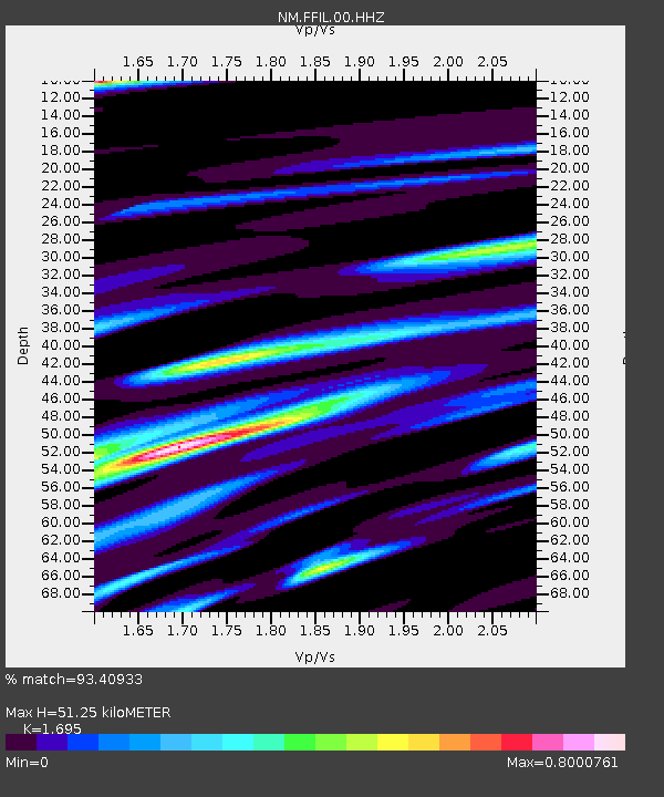
| Estimated Moho Depth: |
51.25 km |
| Estimated Crust Vp/Vs: |
1.70 |
| Assumed Crust Vp: |
6.444 km/s |
| Estimated Crust Vs: |
3.802 km/s |
| Estimated Crust Poisson's Ratio: |
0.23 |
|
| Radial Match: |
93.40933 % |
| Radial Bump: |
361 |
| Transverse Match: |
79.91094 % |
| Transverse Bump: |
400 |
| SOD ConfigId: |
25028951 |
| Insert Time: |
2021-06-14 07:15:33.450 +0000 |
| GWidth: |
2.5 |
| Max Bumps: |
400 |
| Tol: |
0.001 |
|

Signal To Noise
| Channel | StoN | STA | LTA |
| NM:FFIL:00:HHZ:20210531T07:07:19.589004Z | 17.721228 | 2.673259E-6 | 1.5085067E-7 |
| NM:FFIL:00:HHN:20210531T07:07:19.589004Z | 9.960681 | 1.6269253E-6 | 1.6333473E-7 |
| NM:FFIL:00:HHE:20210531T07:07:19.589004Z | 5.9573836 | 1.0828453E-6 | 1.8176524E-7 |
| Arrivals |
| Ps | 5.9 SECOND |
| PpPs | 20 SECOND |
| PsPs/PpSs | 26 SECOND |


