You are here: Home > Network List > XW97 - Tien Shan Continental Dynamics Stations List
> Station KSA XW.KSA > Earthquake Result Viewer
KSA XW.KSA - Earthquake Result Viewer
| Earthquake location: |
Mariana Islands Region |
| Earthquake latitude/longitude: |
17.4/147.5 |
| Earthquake time(UTC): |
2000/05/02 (123) 15:03:36 GMT |
| Earthquake Depth: |
55 km |
| Earthquake Magnitude: |
5.8 MB, 5.9 MW, 5.9 MW |
| Earthquake Catalog/Contributor: |
WHDF/NEIC |
|
| Network: |
XW Tien Shan Continental Dynamics |
| Station: |
KSA XW.KSA |
| Lat/Lon: |
41.54 N/77.93 E |
| Elevation: |
3398 m |
|
| Distance: |
63.5 deg |
| Az: |
308.154 deg |
| Baz: |
89.766 deg |
| Ray Param: |
0.059434433 |
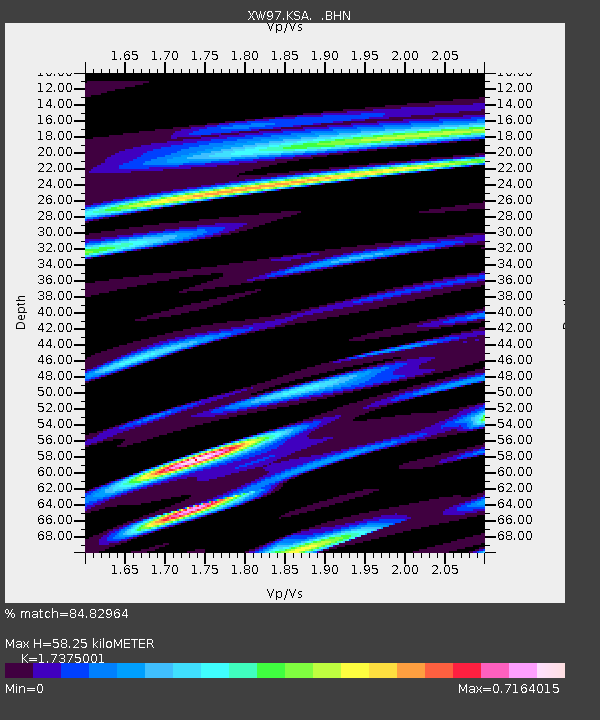
| Estimated Moho Depth: |
58.25 km |
| Estimated Crust Vp/Vs: |
1.74 |
| Assumed Crust Vp: |
6.491 km/s |
| Estimated Crust Vs: |
3.736 km/s |
| Estimated Crust Poisson's Ratio: |
0.25 |
|
| Radial Match: |
84.82964 % |
| Radial Bump: |
400 |
| Transverse Match: |
79.084595 % |
| Transverse Bump: |
400 |
| SOD ConfigId: |
20082 |
| Insert Time: |
2010-02-26 15:38:13.137 +0000 |
| GWidth: |
2.5 |
| Max Bumps: |
400 |
| Tol: |
0.001 |
|
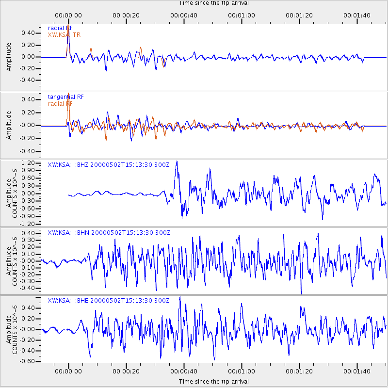
Signal To Noise
| Channel | StoN | STA | LTA |
| XW:KSA: :BHN:20000502T15:13:30.300Z | 0.6816359 | 1.6305833E-8 | 2.3921618E-8 |
| XW:KSA: :BHE:20000502T15:13:30.300Z | 2.4453304 | 7.615278E-8 | 3.114212E-8 |
| XW:KSA: :BHZ:20000502T15:13:30.300Z | 2.7789788 | 1.3863831E-7 | 4.988822E-8 |
| Arrivals |
| Ps | 6.9 SECOND |
| PpPs | 23 SECOND |
| PsPs/PpSs | 30 SECOND |


