You are here: Home > Network List > XW97 - Tien Shan Continental Dynamics Stations List
> Station KSA XW.KSA > Earthquake Result Viewer
KSA XW.KSA - Earthquake Result Viewer
| Earthquake location: |
Talaud Islands, Indonesia |
| Earthquake latitude/longitude: |
4.1/125.6 |
| Earthquake time(UTC): |
2000/04/03 (094) 15:20:01 GMT |
| Earthquake Depth: |
150 km |
| Earthquake Magnitude: |
5.9 MB, 6.2 MW, 6.0 MW |
| Earthquake Catalog/Contributor: |
WHDF/NEIC |
|
| Network: |
XW Tien Shan Continental Dynamics |
| Station: |
KSA XW.KSA |
| Lat/Lon: |
41.54 N/77.93 E |
| Elevation: |
3398 m |
|
| Distance: |
56.6 deg |
| Az: |
318.313 deg |
| Baz: |
117.903 deg |
| Ray Param: |
0.063570105 |
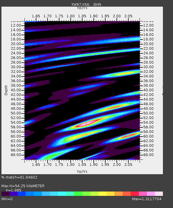
| Estimated Moho Depth: |
54.25 km |
| Estimated Crust Vp/Vs: |
1.87 |
| Assumed Crust Vp: |
6.491 km/s |
| Estimated Crust Vs: |
3.48 km/s |
| Estimated Crust Poisson's Ratio: |
0.30 |
|
| Radial Match: |
81.84602 % |
| Radial Bump: |
400 |
| Transverse Match: |
79.44483 % |
| Transverse Bump: |
400 |
| SOD ConfigId: |
20082 |
| Insert Time: |
2010-02-26 15:38:15.173 +0000 |
| GWidth: |
2.5 |
| Max Bumps: |
400 |
| Tol: |
0.001 |
|

Signal To Noise
| Channel | StoN | STA | LTA |
| XW:KSA: :BHN:20000403T15:28:58.328022Z | 7.434648 | 2.5580457E-7 | 3.4407087E-8 |
| XW:KSA: :BHE:20000403T15:28:58.328022Z | 10.272347 | 4.1668204E-7 | 4.0563467E-8 |
| XW:KSA: :BHZ:20000403T15:28:58.328022Z | 8.322509 | 1.0231214E-6 | 1.2293425E-7 |
| Arrivals |
| Ps | 7.6 SECOND |
| PpPs | 23 SECOND |
| PsPs/PpSs | 30 SECOND |


