You are here: Home > Network List > O2 - Oklahoma Consolidated Temporary Seismic Networks Stations List
> Station SC20 Lookeba, Oklahoma, USA > Earthquake Result Viewer
SC20 Lookeba, Oklahoma, USA - Earthquake Result Viewer
| Earthquake location: |
Central Alaska |
| Earthquake latitude/longitude: |
62.4/-148.3 |
| Earthquake time(UTC): |
2021/05/31 (151) 06:59:54 GMT |
| Earthquake Depth: |
44 km |
| Earthquake Magnitude: |
6.1 Mww |
| Earthquake Catalog/Contributor: |
NEIC PDE/ak |
|
| Network: |
O2 Oklahoma Consolidated Temporary Seismic Networks |
| Station: |
SC20 Lookeba, Oklahoma, USA |
| Lat/Lon: |
35.40 N/98.44 W |
| Elevation: |
490 m |
|
| Distance: |
40.9 deg |
| Az: |
107.644 deg |
| Baz: |
327.15 deg |
| Ray Param: |
0.07401076 |
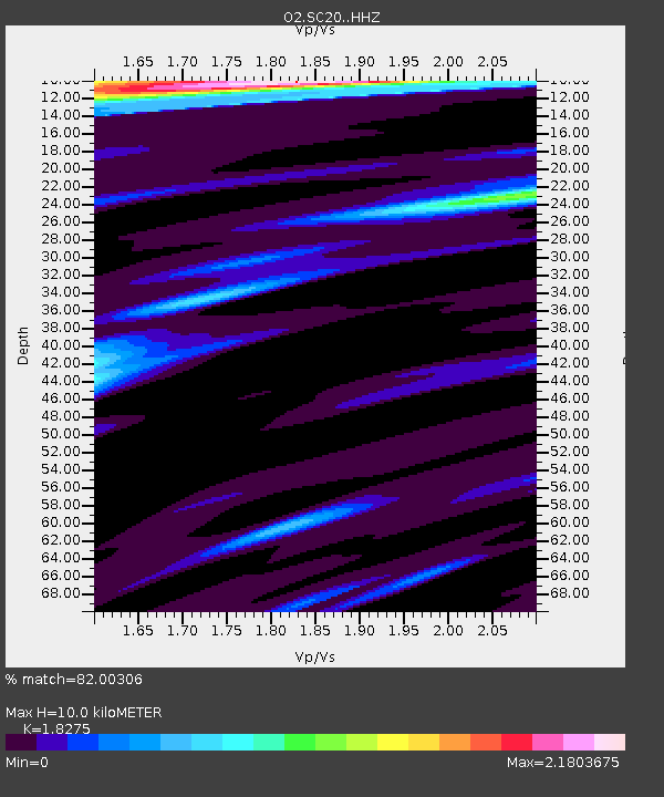
| Estimated Moho Depth: |
10.0 km |
| Estimated Crust Vp/Vs: |
1.83 |
| Assumed Crust Vp: |
6.315 km/s |
| Estimated Crust Vs: |
3.456 km/s |
| Estimated Crust Poisson's Ratio: |
0.29 |
|
| Radial Match: |
82.00306 % |
| Radial Bump: |
400 |
| Transverse Match: |
68.50414 % |
| Transverse Bump: |
400 |
| SOD ConfigId: |
25028951 |
| Insert Time: |
2021-06-14 07:18:19.835 +0000 |
| GWidth: |
2.5 |
| Max Bumps: |
400 |
| Tol: |
0.001 |
|

Signal To Noise
| Channel | StoN | STA | LTA |
| O2:SC20: :HHZ:20210531T07:07:02.259994Z | 11.938396 | 2.131154E-6 | 1.7851258E-7 |
| O2:SC20: :HHN:20210531T07:07:02.259994Z | 3.8905127 | 9.904038E-7 | 2.5456896E-7 |
| O2:SC20: :HHE:20210531T07:07:02.259994Z | 1.9345406 | 5.508698E-7 | 2.8475483E-7 |
| Arrivals |
| Ps | 1.4 SECOND |
| PpPs | 4.2 SECOND |
| PsPs/PpSs | 5.6 SECOND |


