You are here: Home > Network List > TX - Texas Seismological Network Stations List
> Station FW07 Weatherford > Earthquake Result Viewer
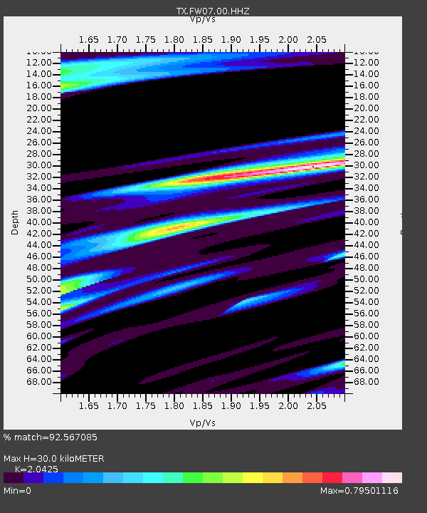
FW07 Weatherford - Earthquake Result Viewer
| Earthquake location: |
Central Alaska |
| Earthquake latitude/longitude: |
62.4/-148.3 |
| Earthquake time(UTC): |
2021/05/31 (151) 06:59:54 GMT |
| Earthquake Depth: |
44 km |
| Earthquake Magnitude: |
6.1 Mww |
| Earthquake Catalog/Contributor: |
NEIC PDE/ak |
|
| Network: |
TX Texas Seismological Network |
| Station: |
FW07 Weatherford |
| Lat/Lon: |
32.70 N/97.79 W |
| Elevation: |
311 m |
|
| Distance: |
43.5 deg |
| Az: |
109.091 deg |
| Baz: |
328.587 deg |
| Ray Param: |
0.072414376 |
| Estimated Moho Depth: |
30.0 km |
| Estimated Crust Vp/Vs: |
2.04 |
| Assumed Crust Vp: |
6.38 km/s |
| Estimated Crust Vs: |
3.124 km/s |
| Estimated Crust Poisson's Ratio: |
0.34 |
|
| Radial Match: |
92.567085 % |
| Radial Bump: |
400 |
| Transverse Match: |
79.927284 % |
| Transverse Bump: |
400 |
| SOD ConfigId: |
25028951 |
| Insert Time: |
2021-06-14 07:23:16.559 +0000 |
| GWidth: |
2.5 |
| Max Bumps: |
400 |
| Tol: |
0.001 |
|

Signal To Noise
| Channel | StoN | STA | LTA |
| TX:FW07:00:HHZ:20210531T07:07:23.159988Z | 23.311684 | 2.3872437E-6 | 1.0240546E-7 |
| TX:FW07:00:HH1:20210531T07:07:23.159988Z | 7.3744903 | 1.0234961E-6 | 1.3878872E-7 |
| TX:FW07:00:HH2:20210531T07:07:23.159988Z | 4.5886507 | 7.070259E-7 | 1.5408143E-7 |
| Arrivals |
| Ps | 5.2 SECOND |
| PpPs | 14 SECOND |
| PsPs/PpSs | 19 SECOND |


