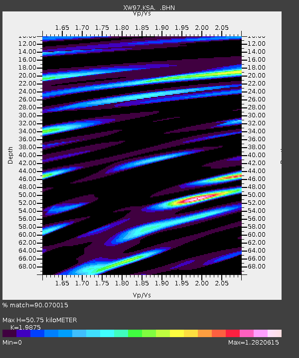
KSA XW.KSA - Earthquake Result Viewer

Earthquake location: Banda Sea
Earthquake latitude/longitude: -7.3/128.5
Earthquake time(UTC): 2000/03/03 (063) 22:09:13 GMT
Earthquake Depth: 142 km
Earthquake Magnitude: 6.4 MB, 5.8 MS, 6.3 MW, 6.3 MW
Earthquake Catalog/Contributor: WHDF/NEIC
Network: XW Tien Shan Continental Dynamics
Station: KSA XW.KSA
Lat/Lon: 41.54 N/77.93 E
Elevation: 3398 m
Distance: 67.1 deg
Az: 320.99 deg
Baz: 123.719 deg
Ray Param: 0.05679755
Estimated Moho Depth: 50.75 km
Estimated Crust Vp/Vs: 1.99
Assumed Crust Vp: 6.491 km/s
Estimated Crust Vs: 3.266 km/s
Estimated Crust Poisson's Ratio: 0.33
Radial Match: 90.070015 %
Radial Bump: 400
Transverse Match: 86.164406 %
Transverse Bump: 400
SOD ConfigId: 20082
Insert Time: 2010-02-26 15:38:21.704 +0000
GWidth: 2.5
Max Bumps: 400
Tol: 0.001

Signal To Noise

ChannelStoNSTALTA
XW:KSA: :BHN:20000303T22:19:21.105002Z6.4534623.3325446E-75.1639642E-8
XW:KSA: :BHE:20000303T22:19:21.105002Z7.02970084.367969E-76.213592E-8
XW:KSA: :BHZ:20000303T22:19:21.105002Z23.5369871.4495712E-66.158695E-8
Arrivals
Ps8.0 SECOND
PpPs23 SECOND
PsPs/PpSs31 SECOND