You are here: Home > Network List > TX - Texas Seismological Network Stations List
> Station PB21 Reeves Ward Border > Earthquake Result Viewer
PB21 Reeves Ward Border - Earthquake Result Viewer
| Earthquake location: |
Central Alaska |
| Earthquake latitude/longitude: |
62.4/-148.3 |
| Earthquake time(UTC): |
2021/05/31 (151) 06:59:54 GMT |
| Earthquake Depth: |
44 km |
| Earthquake Magnitude: |
6.1 Mww |
| Earthquake Catalog/Contributor: |
NEIC PDE/ak |
|
| Network: |
TX Texas Seismological Network |
| Station: |
PB21 Reeves Ward Border |
| Lat/Lon: |
31.34 N/103.06 W |
| Elevation: |
753 m |
|
| Distance: |
42.4 deg |
| Az: |
115.776 deg |
| Baz: |
330.699 deg |
| Ray Param: |
0.07310773 |
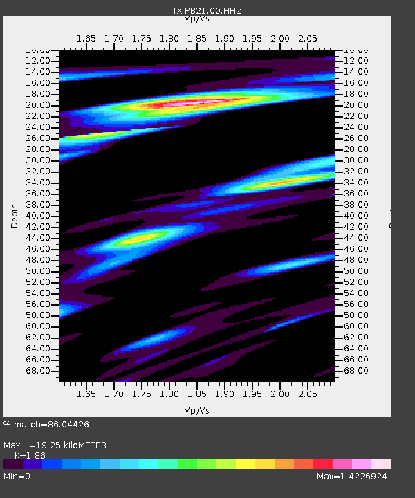
| Estimated Moho Depth: |
19.25 km |
| Estimated Crust Vp/Vs: |
1.86 |
| Assumed Crust Vp: |
6.121 km/s |
| Estimated Crust Vs: |
3.291 km/s |
| Estimated Crust Poisson's Ratio: |
0.30 |
|
| Radial Match: |
86.04426 % |
| Radial Bump: |
400 |
| Transverse Match: |
67.773705 % |
| Transverse Bump: |
400 |
| SOD ConfigId: |
25028951 |
| Insert Time: |
2021-06-14 07:24:07.980 +0000 |
| GWidth: |
2.5 |
| Max Bumps: |
400 |
| Tol: |
0.001 |
|

Signal To Noise
| Channel | StoN | STA | LTA |
| TX:PB21:00:HHZ:20210531T07:07:14.300003Z | 12.256619 | 1.3535797E-6 | 1.1043662E-7 |
| TX:PB21:00:HH1:20210531T07:07:14.300003Z | 7.514271 | 7.8537477E-7 | 1.0451777E-7 |
| TX:PB21:00:HH2:20210531T07:07:14.300003Z | 6.17726 | 4.0942942E-7 | 6.628011E-8 |
| Arrivals |
| Ps | 2.9 SECOND |
| PpPs | 8.5 SECOND |
| PsPs/PpSs | 11 SECOND |


