You are here: Home > Network List > TX - Texas Seismological Network Stations List
> Station PB28 Culberson South > Earthquake Result Viewer
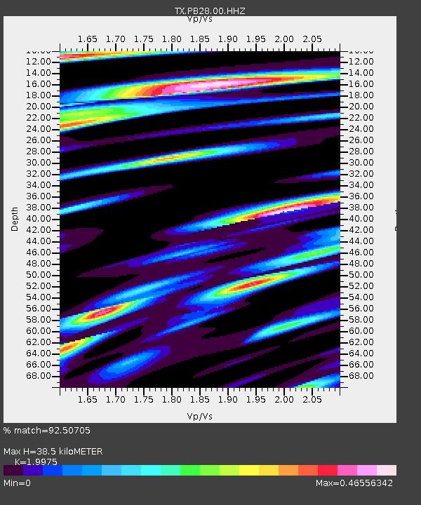
PB28 Culberson South - Earthquake Result Viewer
| Earthquake location: |
Central Alaska |
| Earthquake latitude/longitude: |
62.4/-148.3 |
| Earthquake time(UTC): |
2021/05/31 (151) 06:59:54 GMT |
| Earthquake Depth: |
44 km |
| Earthquake Magnitude: |
6.1 Mww |
| Earthquake Catalog/Contributor: |
NEIC PDE/ak |
|
| Network: |
TX Texas Seismological Network |
| Station: |
PB28 Culberson South |
| Lat/Lon: |
31.67 N/104.50 W |
| Elevation: |
1204 m |
|
| Distance: |
41.5 deg |
| Az: |
117.144 deg |
| Baz: |
330.968 deg |
| Ray Param: |
0.07364174 |
| Estimated Moho Depth: |
38.5 km |
| Estimated Crust Vp/Vs: |
2.00 |
| Assumed Crust Vp: |
6.361 km/s |
| Estimated Crust Vs: |
3.184 km/s |
| Estimated Crust Poisson's Ratio: |
0.33 |
|
| Radial Match: |
92.50705 % |
| Radial Bump: |
400 |
| Transverse Match: |
84.21703 % |
| Transverse Bump: |
400 |
| SOD ConfigId: |
25028951 |
| Insert Time: |
2021-06-14 07:24:10.168 +0000 |
| GWidth: |
2.5 |
| Max Bumps: |
400 |
| Tol: |
0.001 |
|

Signal To Noise
| Channel | StoN | STA | LTA |
| TX:PB28:00:HHZ:20210531T07:07:07.09999Z | 16.417316 | 1.2393881E-6 | 7.5492736E-8 |
| TX:PB28:00:HH1:20210531T07:07:07.09999Z | 11.73614 | 4.2204456E-7 | 3.5961108E-8 |
| TX:PB28:00:HH2:20210531T07:07:07.09999Z | 13.720927 | 3.2952133E-7 | 2.4015966E-8 |
| Arrivals |
| Ps | 6.4 SECOND |
| PpPs | 17 SECOND |
| PsPs/PpSs | 24 SECOND |


