You are here: Home > Network List > TX - Texas Seismological Network Stations List
> Station PB33 CR 111 > Earthquake Result Viewer
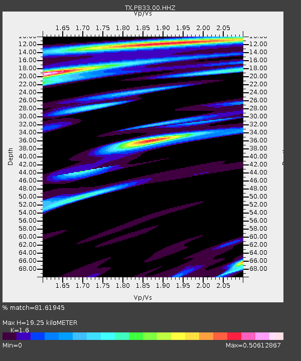
PB33 CR 111 - Earthquake Result Viewer
| Earthquake location: |
Central Alaska |
| Earthquake latitude/longitude: |
62.4/-148.3 |
| Earthquake time(UTC): |
2021/05/31 (151) 06:59:54 GMT |
| Earthquake Depth: |
44 km |
| Earthquake Magnitude: |
6.1 Mww |
| Earthquake Catalog/Contributor: |
NEIC PDE/ak |
|
| Network: |
TX Texas Seismological Network |
| Station: |
PB33 CR 111 |
| Lat/Lon: |
31.53 N/104.05 W |
| Elevation: |
1006 m |
|
| Distance: |
41.8 deg |
| Az: |
116.74 deg |
| Baz: |
330.899 deg |
| Ray Param: |
0.07344925 |
| Estimated Moho Depth: |
19.25 km |
| Estimated Crust Vp/Vs: |
1.60 |
| Assumed Crust Vp: |
6.361 km/s |
| Estimated Crust Vs: |
3.975 km/s |
| Estimated Crust Poisson's Ratio: |
0.18 |
|
| Radial Match: |
81.61945 % |
| Radial Bump: |
400 |
| Transverse Match: |
66.38491 % |
| Transverse Bump: |
400 |
| SOD ConfigId: |
25028951 |
| Insert Time: |
2021-06-14 07:24:16.139 +0000 |
| GWidth: |
2.5 |
| Max Bumps: |
400 |
| Tol: |
0.001 |
|

Signal To Noise
| Channel | StoN | STA | LTA |
| TX:PB33:00:HHZ:20210531T07:07:09.569992Z | 8.984337 | 1.6489184E-6 | 1.8353258E-7 |
| TX:PB33:00:HH1:20210531T07:07:09.569992Z | 1.8520955 | 5.4563077E-7 | 2.9460188E-7 |
| TX:PB33:00:HH2:20210531T07:07:09.569992Z | 2.7450724 | 4.5285012E-7 | 1.6496837E-7 |
| Arrivals |
| Ps | 2.0 SECOND |
| PpPs | 7.3 SECOND |
| PsPs/PpSs | 9.3 SECOND |


