You are here: Home > Network List > US - United States National Seismic Network Stations List
> Station AMTX Amarillo, Texas, USA > Earthquake Result Viewer
AMTX Amarillo, Texas, USA - Earthquake Result Viewer
*The percent match for this event was below the threshold and hence no stack was calculated.
| Earthquake location: |
Central Alaska |
| Earthquake latitude/longitude: |
62.4/-148.3 |
| Earthquake time(UTC): |
2021/05/31 (151) 06:59:54 GMT |
| Earthquake Depth: |
44 km |
| Earthquake Magnitude: |
6.1 Mww |
| Earthquake Catalog/Contributor: |
NEIC PDE/ak |
|
| Network: |
US United States National Seismic Network |
| Station: |
AMTX Amarillo, Texas, USA |
| Lat/Lon: |
34.53 N/101.41 W |
| Elevation: |
1010 m |
|
| Distance: |
40.3 deg |
| Az: |
111.524 deg |
| Baz: |
328.401 deg |
| Ray Param: |
$rayparam |
*The percent match for this event was below the threshold and hence was not used in the summary stack. |
|
| Radial Match: |
95.9281 % |
| Radial Bump: |
400 |
| Transverse Match: |
78.58576 % |
| Transverse Bump: |
400 |
| SOD ConfigId: |
25028951 |
| Insert Time: |
2021-06-14 07:24:48.245 +0000 |
| GWidth: |
2.5 |
| Max Bumps: |
400 |
| Tol: |
0.001 |
|
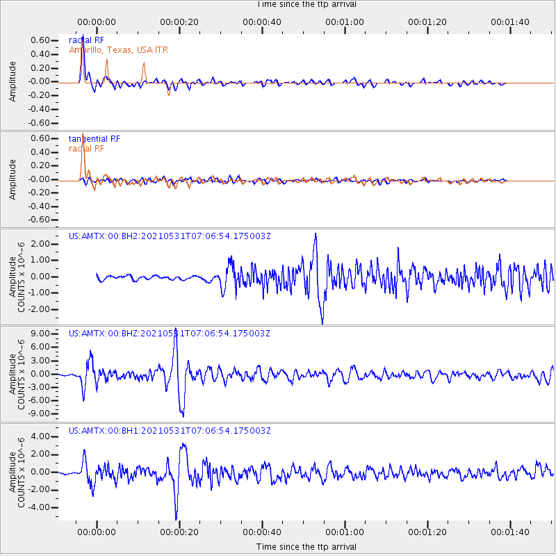
Signal To Noise
| Channel | StoN | STA | LTA |
| US:AMTX:00:BHZ:20210531T07:06:54.175003Z | 12.692748 | 1.3584034E-6 | 1.0702201E-7 |
| US:AMTX:00:BH1:20210531T07:06:54.175003Z | 9.313333 | 9.57312E-7 | 1.02789414E-7 |
| US:AMTX:00:BH2:20210531T07:06:54.175003Z | 4.9250655 | 5.729701E-7 | 1.1633757E-7 |
| Arrivals |
| Ps | |
| PpPs | |
| PsPs/PpSs | |


