You are here: Home > Network List > XW97 - Tien Shan Continental Dynamics Stations List
> Station KSA XW.KSA > Earthquake Result Viewer
KSA XW.KSA - Earthquake Result Viewer
| Earthquake location: |
E. Russia-N.E. China Border Reg. |
| Earthquake latitude/longitude: |
42.9/131.6 |
| Earthquake time(UTC): |
2000/02/13 (044) 02:57:08 GMT |
| Earthquake Depth: |
514 km |
| Earthquake Magnitude: |
5.4 MB, 6.0 MW, 6.0 MW |
| Earthquake Catalog/Contributor: |
WHDF/NEIC |
|
| Network: |
XW Tien Shan Continental Dynamics |
| Station: |
KSA XW.KSA |
| Lat/Lon: |
41.54 N/77.93 E |
| Elevation: |
3398 m |
|
| Distance: |
39.2 deg |
| Az: |
286.954 deg |
| Baz: |
69.562 deg |
| Ray Param: |
0.07262534 |
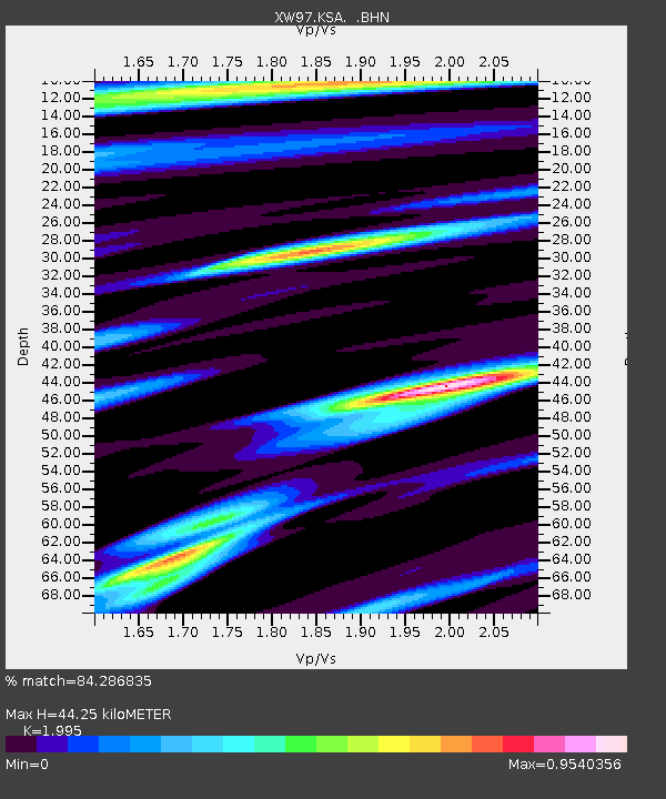
| Estimated Moho Depth: |
44.25 km |
| Estimated Crust Vp/Vs: |
2.00 |
| Assumed Crust Vp: |
6.491 km/s |
| Estimated Crust Vs: |
3.254 km/s |
| Estimated Crust Poisson's Ratio: |
0.33 |
|
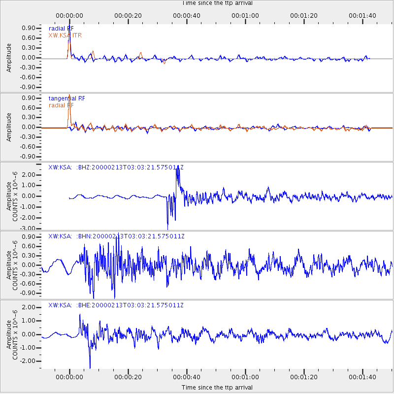
| Radial Match: |
84.286835 % |
| Radial Bump: |
342 |
| Transverse Match: |
64.34709 % |
| Transverse Bump: |
400 |
| SOD ConfigId: |
20082 |
| Insert Time: |
2010-02-26 15:38:29.207 +0000 |
| GWidth: |
2.5 |
| Max Bumps: |
400 |
| Tol: |
0.001 |
|
Signal To Noise
| Channel | StoN | STA | LTA |
| XW:KSA: :BHN:20000213T03:03:21.575011Z | 1.434971 | 1.9882054E-7 | 1.3855372E-7 |
| XW:KSA: :BHE:20000213T03:03:21.575011Z | 2.5070293 | 4.27416E-7 | 1.7048704E-7 |
| XW:KSA: :BHZ:20000213T03:03:21.575011Z | 6.3206406 | 6.9829065E-7 | 1.1047782E-7 |
| Arrivals |
| Ps | 7.2 SECOND |
| PpPs | 19 SECOND |
| PsPs/PpSs | 26 SECOND |


