You are here: Home > Network List > UU - University of Utah Regional Network Stations List
> Station KNB Kanab, UT, USA > Earthquake Result Viewer
KNB Kanab, UT, USA - Earthquake Result Viewer
| Earthquake location: |
Central Alaska |
| Earthquake latitude/longitude: |
62.4/-148.3 |
| Earthquake time(UTC): |
2021/05/31 (151) 06:59:54 GMT |
| Earthquake Depth: |
44 km |
| Earthquake Magnitude: |
6.1 Mww |
| Earthquake Catalog/Contributor: |
NEIC PDE/ak |
|
| Network: |
UU University of Utah Regional Network |
| Station: |
KNB Kanab, UT, USA |
| Lat/Lon: |
37.02 N/112.82 W |
| Elevation: |
1715 m |
|
| Distance: |
33.5 deg |
| Az: |
122.762 deg |
| Baz: |
330.754 deg |
| Ray Param: |
0.07811198 |
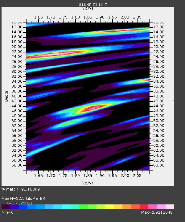
| Estimated Moho Depth: |
22.5 km |
| Estimated Crust Vp/Vs: |
1.73 |
| Assumed Crust Vp: |
6.194 km/s |
| Estimated Crust Vs: |
3.575 km/s |
| Estimated Crust Poisson's Ratio: |
0.25 |
|
| Radial Match: |
91.18899 % |
| Radial Bump: |
365 |
| Transverse Match: |
77.027176 % |
| Transverse Bump: |
388 |
| SOD ConfigId: |
25028951 |
| Insert Time: |
2021-06-14 07:26:03.658 +0000 |
| GWidth: |
2.5 |
| Max Bumps: |
400 |
| Tol: |
0.001 |
|
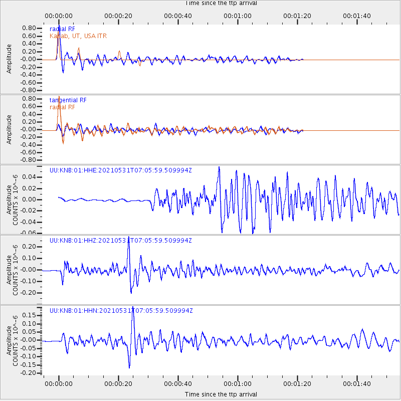
Signal To Noise
| Channel | StoN | STA | LTA |
| UU:KNB:01:HHZ:20210531T07:05:59.509994Z | 23.166658 | 4.2685954E-8 | 1.8425598E-9 |
| UU:KNB:01:HHN:20210531T07:05:59.509994Z | 18.159256 | 2.9470069E-8 | 1.6228677E-9 |
| UU:KNB:01:HHE:20210531T07:05:59.509994Z | 5.9559126 | 1.0004817E-8 | 1.6798126E-9 |
| Arrivals |
| Ps | 2.9 SECOND |
| PpPs | 9.2 SECOND |
| PsPs/PpSs | 12 SECOND |


