You are here: Home > Network List > US - United States National Seismic Network Stations List
> Station EGMT Eagleton, Montana, USA > Earthquake Result Viewer
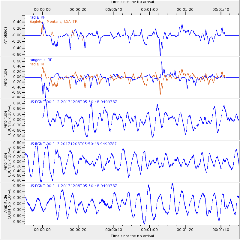
EGMT Eagleton, Montana, USA - Earthquake Result Viewer
*The percent match for this event was below the threshold and hence no stack was calculated.
| Earthquake location: |
W. Caroline Islands, Micronesia |
| Earthquake latitude/longitude: |
10.0/140.1 |
| Earthquake time(UTC): |
2017/12/08 (342) 05:37:54 GMT |
| Earthquake Depth: |
10 km |
| Earthquake Magnitude: |
5.5 mb |
| Earthquake Catalog/Contributor: |
NEIC PDE/us |
|
| Network: |
US United States National Seismic Network |
| Station: |
EGMT Eagleton, Montana, USA |
| Lat/Lon: |
48.02 N/109.75 W |
| Elevation: |
1055 m |
|
| Distance: |
95.7 deg |
| Az: |
39.308 deg |
| Baz: |
291.632 deg |
| Ray Param: |
$rayparam |
*The percent match for this event was below the threshold and hence was not used in the summary stack. |
|
| Radial Match: |
47.17803 % |
| Radial Bump: |
400 |
| Transverse Match: |
67.33186 % |
| Transverse Bump: |
400 |
| SOD ConfigId: |
2429771 |
| Insert Time: |
2017-12-22 05:40:17.266 +0000 |
| GWidth: |
2.5 |
| Max Bumps: |
400 |
| Tol: |
0.001 |
|
Signal To Noise
| Channel | StoN | STA | LTA |
| US:EGMT:00:BHZ:20171208T05:50:48.949978Z | 1.9851202 | 5.554213E-7 | 2.7979232E-7 |
| US:EGMT:00:BH1:20171208T05:50:48.949978Z | 0.54648244 | 2.1600543E-7 | 3.952651E-7 |
| US:EGMT:00:BH2:20171208T05:50:48.949978Z | 1.168674 | 4.249036E-7 | 3.635775E-7 |
| Arrivals |
| Ps | |
| PpPs | |
| PsPs/PpSs | |


