You are here: Home > Network List > UW - Pacific Northwest Regional Seismic Network Stations List
> Station UMAT Pilot Rock, OR, USA > Earthquake Result Viewer
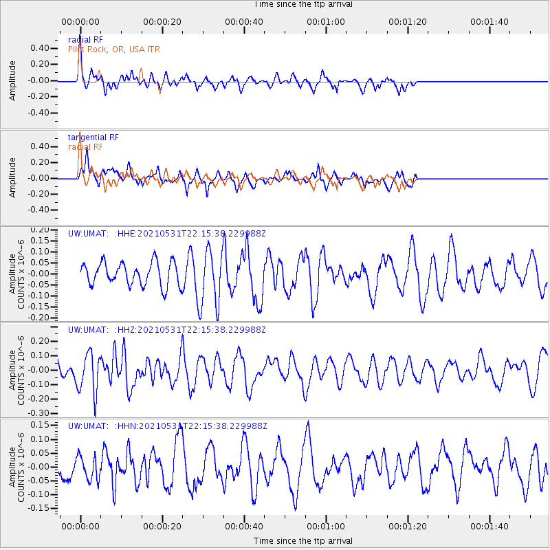
UMAT Pilot Rock, OR, USA - Earthquake Result Viewer
*The percent match for this event was below the threshold and hence no stack was calculated.
| Earthquake location: |
Off East Coast Of Honshu, Japan |
| Earthquake latitude/longitude: |
33.2/142.7 |
| Earthquake time(UTC): |
2021/05/31 (151) 22:04:42 GMT |
| Earthquake Depth: |
10 km |
| Earthquake Magnitude: |
5.2 Mww |
| Earthquake Catalog/Contributor: |
NEIC PDE/us |
|
| Network: |
UW Pacific Northwest Regional Seismic Network |
| Station: |
UMAT Pilot Rock, OR, USA |
| Lat/Lon: |
45.29 N/118.96 W |
| Elevation: |
1318 m |
|
| Distance: |
72.6 deg |
| Az: |
47.055 deg |
| Baz: |
299.572 deg |
| Ray Param: |
$rayparam |
*The percent match for this event was below the threshold and hence was not used in the summary stack. |
|
| Radial Match: |
69.56475 % |
| Radial Bump: |
353 |
| Transverse Match: |
60.067616 % |
| Transverse Bump: |
400 |
| SOD ConfigId: |
25028951 |
| Insert Time: |
2021-06-14 22:25:53.346 +0000 |
| GWidth: |
2.5 |
| Max Bumps: |
400 |
| Tol: |
0.001 |
|
Signal To Noise
| Channel | StoN | STA | LTA |
| UW:UMAT: :HHZ:20210531T22:15:38.229988Z | 1.5497198 | 1.4027937E-7 | 9.051918E-8 |
| UW:UMAT: :HHN:20210531T22:15:38.229988Z | 0.83754236 | 4.315146E-8 | 5.1521525E-8 |
| UW:UMAT: :HHE:20210531T22:15:38.229988Z | 2.5129015 | 1.2901096E-7 | 5.1339438E-8 |
| Arrivals |
| Ps | |
| PpPs | |
| PsPs/PpSs | |


