You are here: Home > Network List > KZ - Kazakhstan Network Stations List
> Station CHK Chkalovo, Kazakstan > Earthquake Result Viewer
CHK Chkalovo, Kazakstan - Earthquake Result Viewer
| Earthquake location: |
Kuril Islands |
| Earthquake latitude/longitude: |
43.7/147.3 |
| Earthquake time(UTC): |
1994/10/04 (277) 13:22:58 GMT |
| Earthquake Depth: |
33 km |
| Earthquake Magnitude: |
7.4 MB, 8.1 MS, 8.3 UNKNOWN, 8.2 MW |
| Earthquake Catalog/Contributor: |
WHDF/NEIC |
|
| Network: |
KZ Kazakhstan Network |
| Station: |
CHK Chkalovo, Kazakstan |
| Lat/Lon: |
53.68 N/70.62 E |
| Elevation: |
120 m |
|
| Distance: |
49.3 deg |
| Az: |
310.169 deg |
| Baz: |
68.666 deg |
| Ray Param: |
0.06874903 |
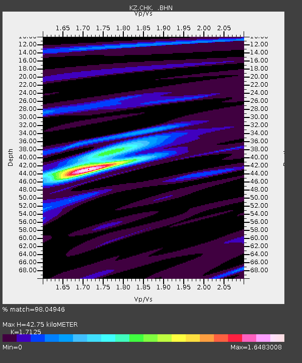
| Estimated Moho Depth: |
42.75 km |
| Estimated Crust Vp/Vs: |
1.71 |
| Assumed Crust Vp: |
6.552 km/s |
| Estimated Crust Vs: |
3.826 km/s |
| Estimated Crust Poisson's Ratio: |
0.24 |
|
| Radial Match: |
98.04946 % |
| Radial Bump: |
383 |
| Transverse Match: |
91.25673 % |
| Transverse Bump: |
400 |
| SOD ConfigId: |
17000 |
| Insert Time: |
2010-03-09 08:52:57.617 +0000 |
| GWidth: |
2.5 |
| Max Bumps: |
400 |
| Tol: |
0.001 |
|

Signal To Noise
| Channel | StoN | STA | LTA |
| KZ:CHK: :BHN:19941004T13:31:13.18501Z | 16.50543 | 1.3337424E-6 | 8.0806274E-8 |
| KZ:CHK: :BHE:19941004T13:31:13.18501Z | 4.8080983 | 2.6939742E-6 | 5.602993E-7 |
| KZ:CHK: :BHZ:19941004T13:31:13.18501Z | 9.345961 | 5.175772E-6 | 5.5379775E-7 |
| Arrivals |
| Ps | 5.0 SECOND |
| PpPs | 17 SECOND |
| PsPs/PpSs | 22 SECOND |


