You are here: Home > Network List > KZ - Kazakhstan Network Stations List
> Station CHK Chkalovo, Kazakstan > Earthquake Result Viewer
CHK Chkalovo, Kazakstan - Earthquake Result Viewer
| Earthquake location: |
Ryukyu Islands, Japan |
| Earthquake latitude/longitude: |
28.1/130.3 |
| Earthquake time(UTC): |
1995/10/19 (292) 02:41:37 GMT |
| Earthquake Depth: |
31 km |
| Earthquake Magnitude: |
6.3 MB, 6.8 MS, 6.6 UNKNOWN, 6.6 MW |
| Earthquake Catalog/Contributor: |
WHDF/NEIC |
|
| Network: |
KZ Kazakhstan Network |
| Station: |
CHK Chkalovo, Kazakstan |
| Lat/Lon: |
53.68 N/70.62 E |
| Elevation: |
120 m |
|
| Distance: |
50.1 deg |
| Az: |
317.963 deg |
| Baz: |
95.977 deg |
| Ray Param: |
0.068229616 |
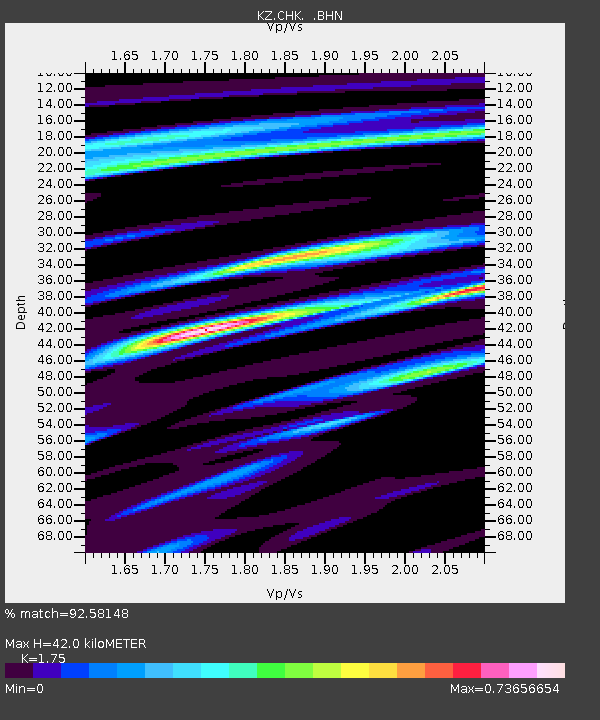
| Estimated Moho Depth: |
42.0 km |
| Estimated Crust Vp/Vs: |
1.75 |
| Assumed Crust Vp: |
6.552 km/s |
| Estimated Crust Vs: |
3.744 km/s |
| Estimated Crust Poisson's Ratio: |
0.26 |
|
| Radial Match: |
92.58148 % |
| Radial Bump: |
397 |
| Transverse Match: |
78.53742 % |
| Transverse Bump: |
400 |
| SOD ConfigId: |
6273 |
| Insert Time: |
2010-03-09 08:53:57.135 +0000 |
| GWidth: |
2.5 |
| Max Bumps: |
400 |
| Tol: |
0.001 |
|

Signal To Noise
| Channel | StoN | STA | LTA |
| KZ:CHK: :BHN:19951019T02:49:59.284003Z | 0.5337901 | 1.126851E-7 | 2.1110378E-7 |
| KZ:CHK: :BHE:19951019T02:49:59.284003Z | 3.2939005 | 3.3037884E-7 | 1.0030019E-7 |
| KZ:CHK: :BHZ:19951019T02:49:59.284003Z | 2.279758 | 5.640493E-7 | 2.474163E-7 |
| Arrivals |
| Ps | 5.1 SECOND |
| PpPs | 17 SECOND |
| PsPs/PpSs | 22 SECOND |


