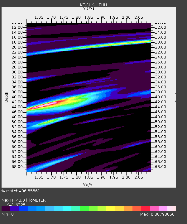
CHK Chkalovo, Kazakstan - Earthquake Result Viewer

Earthquake location: South Of Sumbawa, Indonesia
Earthquake latitude/longitude: -11.2/118.7
Earthquake time(UTC): 1996/02/12 (043) 09:08:10 GMT
Earthquake Depth: 33 km
Earthquake Magnitude: 5.8 MB, 5.8 MS, 6.1 UNKNOWN, 6.0 MW
Earthquake Catalog/Contributor: WHDF/NEIC
Network: KZ Kazakhstan Network
Station: CHK Chkalovo, Kazakstan
Lat/Lon: 53.68 N/70.62 E
Elevation: 120 m
Distance: 76.4 deg
Az: 332.918 deg
Baz: 131.326 deg
Ray Param: 0.050997756
Estimated Moho Depth: 43.0 km
Estimated Crust Vp/Vs: 1.67
Assumed Crust Vp: 6.552 km/s
Estimated Crust Vs: 3.918 km/s
Estimated Crust Poisson's Ratio: 0.22
Radial Match: 96.55561 %
Radial Bump: 344
Transverse Match: 84.70471 %
Transverse Bump: 400
SOD ConfigId: 6273
Insert Time: 2010-03-09 08:54:39.936 +0000
GWidth: 2.5
Max Bumps: 400
Tol: 0.001

Signal To Noise

ChannelStoNSTALTA
KZ:CHK: :BHN:19960212T09:19:25.462Z1.88646881.19148496E-76.315954E-8
KZ:CHK: :BHE:19960212T09:19:25.462Z1.13019741.1370495E-71.0060627E-7
KZ:CHK: :BHZ:19960212T09:19:25.462Z2.54438232.3247759E-79.136897E-8
Arrivals
Ps4.6 SECOND
PpPs17 SECOND
PsPs/PpSs22 SECOND