You are here: Home > Network List > UW - Pacific Northwest Regional Seismic Network Stations List
> Station HOOD Mt Hood Meadows, OR CREST BB SMO > Earthquake Result Viewer
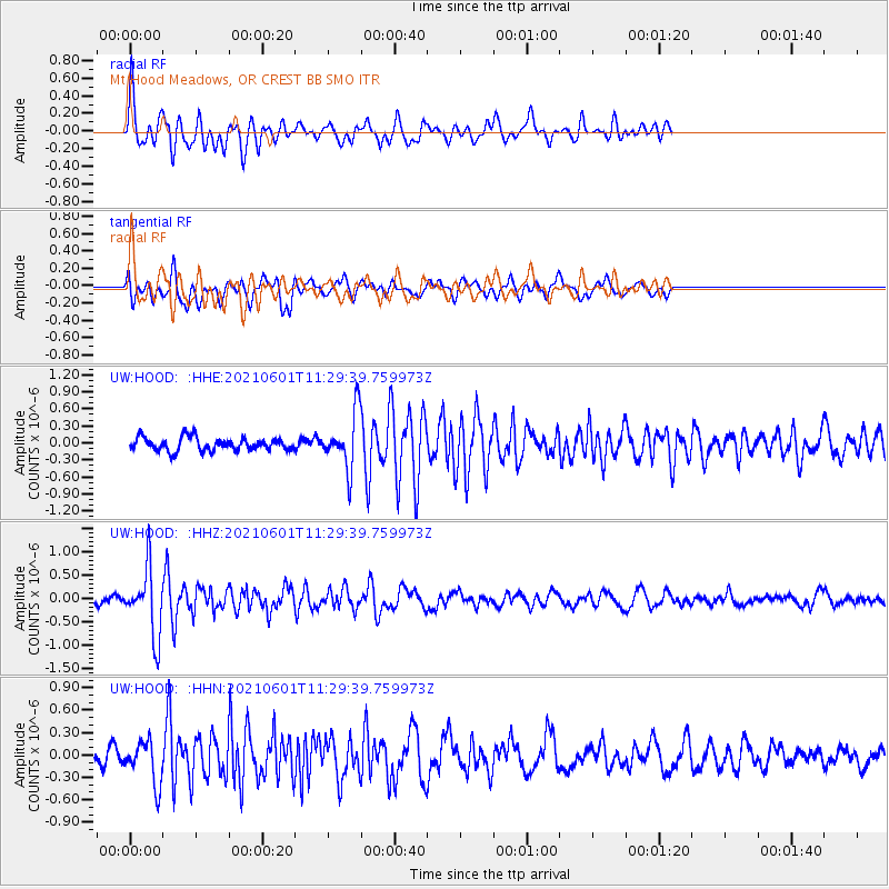
HOOD Mt Hood Meadows, OR CREST BB SMO - Earthquake Result Viewer
*The percent match for this event was below the threshold and hence no stack was calculated.
| Earthquake location: |
South Of Panama |
| Earthquake latitude/longitude: |
5.0/-82.7 |
| Earthquake time(UTC): |
2021/06/01 (152) 11:20:57 GMT |
| Earthquake Depth: |
10 km |
| Earthquake Magnitude: |
5.5 mww |
| Earthquake Catalog/Contributor: |
NEIC PDE/us |
|
| Network: |
UW Pacific Northwest Regional Seismic Network |
| Station: |
HOOD Mt Hood Meadows, OR CREST BB SMO |
| Lat/Lon: |
45.32 N/121.65 W |
| Elevation: |
1520 m |
|
| Distance: |
52.5 deg |
| Az: |
326.023 deg |
| Baz: |
127.898 deg |
| Ray Param: |
$rayparam |
*The percent match for this event was below the threshold and hence was not used in the summary stack. |
|
| Radial Match: |
78.04067 % |
| Radial Bump: |
400 |
| Transverse Match: |
66.95372 % |
| Transverse Bump: |
400 |
| SOD ConfigId: |
25028951 |
| Insert Time: |
2021-06-15 11:49:52.696 +0000 |
| GWidth: |
2.5 |
| Max Bumps: |
400 |
| Tol: |
0.001 |
|
Signal To Noise
| Channel | StoN | STA | LTA |
| UW:HOOD: :HHZ:20210601T11:29:39.759973Z | 6.97505 | 7.176382E-7 | 1.0288647E-7 |
| UW:HOOD: :HHN:20210601T11:29:39.759973Z | 2.0676224 | 2.8986122E-7 | 1.4019061E-7 |
| UW:HOOD: :HHE:20210601T11:29:39.759973Z | 4.2205906 | 4.7903586E-7 | 1.1349973E-7 |
| Arrivals |
| Ps | |
| PpPs | |
| PsPs/PpSs | |


