You are here: Home > Network List > KZ - Kazakhstan Network Stations List
> Station CHK Chkalovo, Kazakstan > Earthquake Result Viewer
CHK Chkalovo, Kazakstan - Earthquake Result Viewer
| Earthquake location: |
Arabian Sea |
| Earthquake latitude/longitude: |
12.4/58.1 |
| Earthquake time(UTC): |
1996/10/01 (275) 15:50:23 GMT |
| Earthquake Depth: |
10 km |
| Earthquake Magnitude: |
5.8 MB, 5.9 MS, 6.4 UNKNOWN, 6.3 MW |
| Earthquake Catalog/Contributor: |
WHDF/NEIC |
|
| Network: |
KZ Kazakhstan Network |
| Station: |
CHK Chkalovo, Kazakstan |
| Lat/Lon: |
53.68 N/70.62 E |
| Elevation: |
120 m |
|
| Distance: |
42.3 deg |
| Az: |
11.066 deg |
| Baz: |
198.371 deg |
| Ray Param: |
0.07323449 |
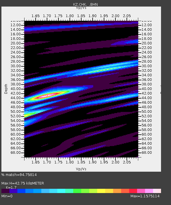
| Estimated Moho Depth: |
42.75 km |
| Estimated Crust Vp/Vs: |
1.70 |
| Assumed Crust Vp: |
6.552 km/s |
| Estimated Crust Vs: |
3.854 km/s |
| Estimated Crust Poisson's Ratio: |
0.24 |
|
| Radial Match: |
94.75814 % |
| Radial Bump: |
363 |
| Transverse Match: |
47.197926 % |
| Transverse Bump: |
400 |
| SOD ConfigId: |
6273 |
| Insert Time: |
2010-03-09 08:55:28.998 +0000 |
| GWidth: |
2.5 |
| Max Bumps: |
400 |
| Tol: |
0.001 |
|

Signal To Noise
| Channel | StoN | STA | LTA |
| KZ:CHK: :BHN:19961001T15:57:46.740015Z | 6.1426377 | 1.8692738E-7 | 3.0431128E-8 |
| KZ:CHK: :BHE:19961001T15:57:46.740015Z | 0.65280765 | 8.819895E-8 | 1.351071E-7 |
| KZ:CHK: :BHZ:19961001T15:57:46.740015Z | 8.163345 | 3.915875E-7 | 4.7968992E-8 |
| Arrivals |
| Ps | 4.9 SECOND |
| PpPs | 16 SECOND |
| PsPs/PpSs | 21 SECOND |


