You are here: Home > Network List > AK - Alaska Regional Network Stations List
> Station B18K Kokolik River, AK, USA > Earthquake Result Viewer
B18K Kokolik River, AK, USA - Earthquake Result Viewer
| Earthquake location: |
Northern Molucca Sea |
| Earthquake latitude/longitude: |
0.3/126.3 |
| Earthquake time(UTC): |
2021/06/03 (154) 10:09:55 GMT |
| Earthquake Depth: |
9.9 km |
| Earthquake Magnitude: |
6.1 Mww |
| Earthquake Catalog/Contributor: |
NEIC PDE/us |
|
| Network: |
AK Alaska Regional Network |
| Station: |
B18K Kokolik River, AK, USA |
| Lat/Lon: |
69.36 N/161.80 W |
| Elevation: |
222 m |
|
| Distance: |
83.4 deg |
| Az: |
19.825 deg |
| Baz: |
253.075 deg |
| Ray Param: |
0.04623719 |
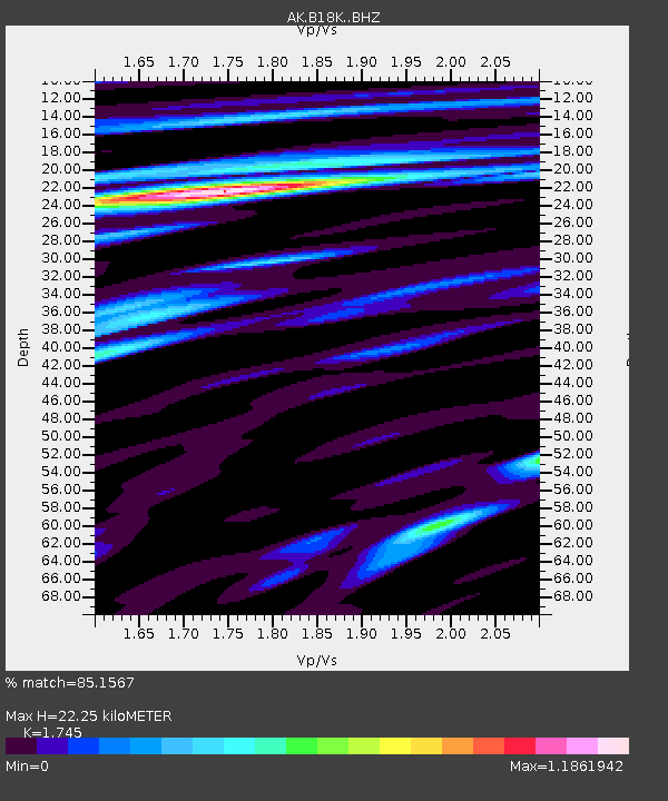
| Estimated Moho Depth: |
22.25 km |
| Estimated Crust Vp/Vs: |
1.75 |
| Assumed Crust Vp: |
5.906 km/s |
| Estimated Crust Vs: |
3.385 km/s |
| Estimated Crust Poisson's Ratio: |
0.26 |
|
| Radial Match: |
85.1567 % |
| Radial Bump: |
400 |
| Transverse Match: |
81.10999 % |
| Transverse Bump: |
400 |
| SOD ConfigId: |
25131211 |
| Insert Time: |
2021-06-17 10:10:16.080 +0000 |
| GWidth: |
2.5 |
| Max Bumps: |
400 |
| Tol: |
0.001 |
|

Signal To Noise
| Channel | StoN | STA | LTA |
| AK:B18K: :BHZ:20210603T10:21:51.76003Z | 6.917888 | 1.0947074E-6 | 1.5824301E-7 |
| AK:B18K: :BHN:20210603T10:21:51.76003Z | 1.3551607 | 2.2202055E-7 | 1.6383336E-7 |
| AK:B18K: :BHE:20210603T10:21:51.76003Z | 1.3883806 | 1.7819674E-7 | 1.2834862E-7 |
| Arrivals |
| Ps | 2.9 SECOND |
| PpPs | 10 SECOND |
| PsPs/PpSs | 13 SECOND |


