You are here: Home > Network List > KZ - Kazakhstan Network Stations List
> Station CHK Chkalovo, Kazakstan > Earthquake Result Viewer
CHK Chkalovo, Kazakstan - Earthquake Result Viewer
| Earthquake location: |
Seram, Indonesia |
| Earthquake latitude/longitude: |
-4.0/128.1 |
| Earthquake time(UTC): |
1996/12/30 (365) 19:41:52 GMT |
| Earthquake Depth: |
33 km |
| Earthquake Magnitude: |
6.0 MB, 5.9 MS, 6.2 UNKNOWN, 6.0 MW |
| Earthquake Catalog/Contributor: |
WHDF/NEIC |
|
| Network: |
KZ Kazakhstan Network |
| Station: |
CHK Chkalovo, Kazakstan |
| Lat/Lon: |
53.68 N/70.62 E |
| Elevation: |
120 m |
|
| Distance: |
74.7 deg |
| Az: |
328.663 deg |
| Baz: |
119.3 deg |
| Ray Param: |
0.05208993 |
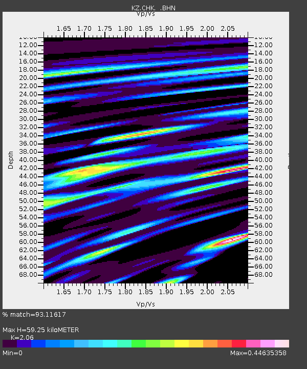
| Estimated Moho Depth: |
59.25 km |
| Estimated Crust Vp/Vs: |
2.06 |
| Assumed Crust Vp: |
6.552 km/s |
| Estimated Crust Vs: |
3.181 km/s |
| Estimated Crust Poisson's Ratio: |
0.35 |
|
| Radial Match: |
93.11617 % |
| Radial Bump: |
400 |
| Transverse Match: |
82.60989 % |
| Transverse Bump: |
400 |
| SOD ConfigId: |
6273 |
| Insert Time: |
2010-03-09 08:55:40.731 +0000 |
| GWidth: |
2.5 |
| Max Bumps: |
400 |
| Tol: |
0.001 |
|

Signal To Noise
| Channel | StoN | STA | LTA |
| KZ:CHK: :BHN:19961230T19:52:57.517029Z | 2.3289888 | 1.3113846E-7 | 5.6307037E-8 |
| KZ:CHK: :BHE:19961230T19:52:57.517029Z | 5.700635 | 2.7098002E-7 | 4.7535057E-8 |
| KZ:CHK: :BHZ:19961230T19:52:57.517029Z | 11.555828 | 7.529161E-7 | 6.515466E-8 |
| Arrivals |
| Ps | 9.9 SECOND |
| PpPs | 27 SECOND |
| PsPs/PpSs | 37 SECOND |


